|
4. VILLAGE OF RICHMOND COMMUNITY DESIGN PLAN, OFFICIAL
PLAN AMENDMENT, ZONING BY-LAW AMENDMENT, VILLAGE OF RICHMOND WATER AND
SANITARY MASTER SERVICING STUDY AND CLASS ENVIRONMENTAL ASSESSMENT PHASES 1,
2, 3 AND 4, VILLAGE OF RICHMOND ENVIRONMENTAL MANAGEMENT PLAN AND VILLAGE OF
RICHMOND TRANSPORTATION MASTER PLAN (FILE NO. [D03-01-08
RICH]) PLAN
DE CONCEPTION COMMUNAUTAIRE DU VILLAGE DE RICHMOND, MODIFICATION DU PLAN
OFFICIEL, MODIFICATION DU RÈGLEMENT DE ZONAGE, PLAN DIRECTEUR DE
VIABILISATION ET ÉVALUATION ENVIRONNEMENTALE DE PORTÉE GÉNÉRALE PHASES 1, 2,
3 ET 4 DES SERVICES D’EAUX ET D’ÉGOUTS DU VILLAGE DE RICHMOND, PLAN DE
GESTION ENVIRONNEMENTALE DU VILLAGE DE RICHMOND ET PLAN DIRECTEUR DES
TRANSPORTS DU VILLAGE DE RICHMOND |
Committee RecommendationS AS AMENDED
That Council :
1. Approve the Richmond
Community Design Plan in Document 3, which has been submitted under separate
cover;
2. Adopt Official Plan
Amendment No. XX (Richmond Secondary Plan) to the City of Ottawa Official Plan,
as detailed in Document 8;
3. Approve the zoning changes to implement the Richmond Community
Design Plan as detailed in Document 9;
4. Endorse the recommended water and wastewater projects identified
in Document 13 - Village of Richmond Water and Sanitary Master Servicing Study
and Class Environmental Assessment Phases 1, 2, 3, and 4 Draft (May 2010);
5. Endorse the transportation recommendations identified in
Document 15 entitled Village of Richmond Transportation Master Plan (June
2010);
6. Approve the Village of Richmond Environmental Management Plan
(Document 11) that includes infrastructure and capital improvements to the
Richmond Conservation Area, City-owned properties and parks; and
7. Direct staff to report back to the Agriculture and Rural
Affairs Committee and City Council on the financial implications of the
servicing recommendations;
8. That the
following be added after Policy 6 in subsection 3.6 of the Secondary Plan for
the Village of Richmond:
“7. Notwithstanding
the requirement to complete a review by June 2014 of employment land needs and
other issues, the City shall undertake a review of the Industrial lands in
Richmond (long-term employment and land supply) in consultation with the land
owners and shall report back to Agriculture and Rural Affairs Committee within
two years.”
9. That
the Financial Plan:
a) Does not have adverse impact on any current Capital budgets and/or
Development Charges revenues anticipated for the life of the current Official
Plan;
b) Includes an estimate of the total cost of extending communal well
services to the portion of the existing Village served by private wells;
c) Recommends funding options for the extension of water service as
referred to in b) above, including possible creation of reserves from a new
Richmond Development Charges By-Law.
10. That staff be directed to require the completion of an
Environmental Assessment to assess the stormwater solution that would provide a
review of the location of the stormwater pond, the collection system and
foundation drainage.
RecommandationS MODIFIÉES DU Comité
Que le Conseil:
1.
approuve le Plan de conception
communautaire de Richmond (document 3), déposé sous pli distinct;
2.
adopte la modification no
XX (plan secondaire de Richmond) du Plan officiel de la Ville d’Ottawa
présentée en détail dans le document 8;
3.
approuve les changements du
Règlement de zonage pour mettre en œuvre le Plan de conception communautaire de
Richmond comme décrit dans le document 9;
4.
appuye les projets recommandés en
matière d’eaux et d’égouts identifiés dans le document 13 - Plan directeur
de viabilisation et Évaluation environnementale de portée générale phases 1, 2,
3 et 4 préliminaires pour les travaux de raccordement du village de Richmond
(mai 2010);
5.
appuyé les recommandations en
matière de transport formulées dans le document 15 et intitulé Plan
directeur des transports du village de Richmond (juin 2010);
6.
approuve le Plan de gestion
environnementale du village de Richmond (document 11) qui comprend des
améliorations aux infrastructures et immobilisations de la zone de conservation
de Richmond et des propriétés et parcs appartenant à la Ville;
7.
Mandate le personnel pour remettre
un rapport au Comité de l’agriculture et des affaires rurales et au Conseil
municipal entourant les répercussions financières des recommandations de
viabilisation des terrains.
8. Que
le passage suivant soit ajouté après la politique 6 à la sous-section 3.6 du
Plan secondaire pour le Village de
Richmond :
« 7. Nonobstant
l’obligation de procéder d’ici au mois de juin 2014 à un examen des besoins en
zones d’emplois et d’autres questions, la Ville effectuera, de concert avec les
propriétaires, un examen des terrains industriels de Richmond (offre d’emplois
et de terrains à long terme) et fera rapport au Comité de l’agriculture et des
affaires rurales dans un délai de deux ans. »
9. Que
le Plan financier :
a) N’ait
pas d’impact négatif sur les budgets d’immobilisations actuels ni sur les
recettes devant être tirées des redevances d’aménagement pendant la durée de
l’actuel Plan officiel;
b) Comprenne
une estimation du coût total de l’élargissement des services de puits communaux
à la partie du village alimentée en eau au moyen de puits privés;
c) recommande
différentes options pour le financement de l’élargissement du service
d’alimentation en eau visé au paragraphe (b), y compris l’établissement
éventuel de réserves au moyen d’un nouveau règlement sur les redevances
d’aménagement pour le Village de Richmond.
10. Que le personnel reçoive instruction
d’exiger une évaluation environnementale qui tiendrait compte de la solution
fondée sur la gestion des eaux pluviales et qui donnerait lieu à un examen de
l’emplacement du bassin d’eaux pluviales, du système de collecte et du drainage
de fondation.
Documentation
1. Deputy City Manager’s Report, Infrastructure Services and Community Sustainability dated 25 June 2010 (ACS2010-ICS-PGM-0122).
2. Extract of Draft Minute, 8 July 2010 (more detailed Extract of Draft Minute may be issued separately prior to Council meeting of 14 July 2010).
Report to/Rapport au :
Agriculture and Rural Affairs Committee
Comité d'agriculture et des affaires rurales
and Council/et au Conseil
25 June 2010 / le 25 juin 2010
Submitted by/Soumis par : Nancy Schepers, Deputy City
Manager/Directrice municipale adjointe, Infrastructure Services and Community Sustainability, Services d'infrastructure et Viabilité des collectivités
Contact Person/Personne-ressource : Richard Kilstrom, Manager/Gestionnaire,
Policy Development and Urban Design Branch/ Unité de l’esthétique urbaine et de la conception communautaire, Planning and Growth Management/Urbanisme et Gestion de
la croissance
(613) 580-2424, 22379 Richard.Kilstrom@ottawa.ca
REPORT RECOMMENDATIONS
That the Agriculture and Rural Affairs
Committee recommend Council:
1. Approve the Richmond Community
Design Plan in Document 3, which has been submitted under separate cover;
2. Adopt
Official Plan Amendment No. XX (Richmond Secondary Plan) to the City of Ottawa
Official Plan, as detailed in Document 8;
3.
Approve the zoning changes
to implement the Richmond Community Design Plan as detailed in Document 9;
4.
Endorse the recommended
water and wastewater projects identified in Document 13 - Village of Richmond
Water and Sanitary Master Servicing Study and Class Environmental Assessment
Phases 1, 2, 3, and 4 Draft (May 2010);
5.
Endorse the transportation
recommendations identified in Document 15 entitled Village of Richmond
Transportation Master Plan (June 2010);
6.
Approve the Village of
Richmond Environmental Management Plan (Document 11) that includes
infrastructure and capital improvements to the Richmond Conservation Area,
City-owned properties and parks; and
7.
Direct staff to report back
to the Agriculture and Rural Affairs Committee and City Council on the
financial implications of the servicing recommendations.
RECOMMANDATIONS DU
RAPPORT
Que le Comité de l’agriculture et des affaires rurales recommande au
conseil municipal :
1.
D’approuver le Plan de conception
communautaire de Richmond (document 3), déposé sous pli distinct;
2.
D’adopter la modification no
XX (plan secondaire de Richmond) du Plan officiel de la Ville d’Ottawa
présentée en détail dans le document 8;
3.
D’approuver les changements du
Règlement de zonage pour mettre en œuvre le Plan de conception communautaire de
Richmond comme décrit dans le document 9;
4.
D’appuyer les projets recommandés en
matière d’eaux et d’égouts identifiés dans le document 13 - Plan directeur
de viabilisation et Évaluation environnementale de portée générale phases 1, 2,
3 et 4 préliminaires pour les travaux de raccordement du village de Richmond
(mai 2010);
5.
D’appuyer les recommandations en
matière de transport formulées dans le document 15 et intitulé Plan
directeur des transports du village de Richmond (juin 2010);
6.
D’approuver le Plan de gestion
environnementale du village de Richmond (document 11) qui comprend des
améliorations aux infrastructures et immobilisations de la zone de conservation
de Richmond et des propriétés et parcs appartenant à la Ville;
7.
De mandater le personnel pour
remettre un rapport au Comité de l’agriculture et des affaires rurales et au
Conseil municipal entourant les répercussions financières des recommandations
de viabilisation des terrains.
EXECUTIVE SUMMARY
Assumptions and Analysis
A community design plan (CDP) for the Village
of Richmond was prepared to guide village growth over the next 20 years. Staff worked with a Steering Committee
representing residents, farmers, landowners, developers, and business people to
develop a plan that would be a reflection of their aspirations for their
community. Meetings were organized to
obtain residents’ ideas which were then developed into a vision, which has
served to guide development of the Richmond CDP.
The focus of Richmond will be a Village Core
centered around the McBean/Perth intersection, which will be a pedestrian-oriented
mixed-use area that will develop over time.
Limited pockets of commercial development located outside this area will
be permitted but are not intended to compete with the Village Core. The current industrial area will retain its
current Industrial designation, which will serve to protect future employment
opportunities as directed in the Provincial Policy Statement.
A green corridor, including a multi-use pathway
system, linking the Richmond Conservation Area and the northerly end of the
Marlborough Forest, is discussed in the Richmond Environmental
Management Plan. A funding mechanism
through a Rideau Valley Conservation Authority levy will ensure proper
maintenance of this corridor in the future.
The majority of Richmond is designated Residential
with policies and guidelines to provide direction on future development.
The Western Development Lands will have a
variety of housing types and higher residential densities than is currently
permitted in the Zoning By-law. Housing
ranging from single detached dwellings to back-to-back townhouses are
proposed. Residential densities will
range from 17 dwelling units per hectare to a maximum of 99 dwelling units per
hectare, depending on housing type.
Mattamy submitted an Official Plan Amendment application
and various supporting studies, including a Master Servicing Study (MSS)
following the Municipal Class Environmental Assessment process and a
village-wide transportation master plan (TMP).
The Richmond CDP draws upon the results of these two studies.
The staff report recommends endorsement of two
projects identified in the MSS: i)
expansion of the existing wastewater system in Richmond, and ii) a public
communal well system to serve the Western Development Lands. Sufficient time was not available to review
and provide comments on the draft MSS report.
Staff recommends that the comments that they will be providing be
addressed and accommodated by Mattamy before they file their Notice of
Completion. Similarly, more discussions
between City staff and Mattamy needs to be held regarding the financial
implications of the projects for the City.
Since the Village is approaching 1800
households, the maximum number that can be serviced by the existing wastewater
system, future development applications will be required to show that there is
capacity in the existing wastewater system.
Transportation infrastructure projects are
identified that will be required as the Western Development Lands and the
remainder of the Village develops.
Legal/Risk Management Implications:
If the Official Plan Amendment and Zoning
By-law Amendment were appealed to the Ontario Municipal Board, it is
anticipated that a hearing of approximately five days duration would
result. The hearing could likely be conducted within staff resources.
If the Official Plan Amendment is refused, as
it is a result of an application, reasons must be provided. The zoning
has been initiated by the City and therefore reasons may but do not have to be
provided should it be refused.
Technical Implications:
N/A
Financial Implications
Recommendations
as a result of the Village of Richmond Water and Sanitary Master Servicing
Study result in a Total Water Servicing - Communal Well Systems Phasing Plan of
$14.3 Million and a Total Wastewater (Sanitary) Servicing Phasing Plan of $22.2
Million. Further discussions are required to establish costs splits
between the City, Mattamy and other stakeholders. The City’s financial contributions to
infrastructure works in Richmond will be consistent with its growth management
strategy, past rural servicing practices and the overall approach employed in
the Development Charge Background Study.
The village servicing calculation employed will match the capital needs to the growth that
benefits from the forecasted works.
Therefore, the appropriate funding arrangement
will include area-specific charges that result in a more accurate distribution
of costs and facilitate front-end financing arrangements for the designated
services. Alternative infrastructure
funding proposals may be considered as part of the village servicing
plans.
Of the total $32,570,000 identified to
implement transportation infrastructure projects identified in the Village of
Richmond Transportation Master Plan, the City’s cost is anticipated to be
$680,000.
The
Environmental Management Plan identifies capital projects and estimates the
cost to upgrade amenities in the public properties along the Jock River.
Projects could be funded from a variety of sources including the
Rideau Valley Conservation Authority levy, Cash In Lieu of Parkland Reserves
and partnership agreements. On-going maintenance costs need to be
addressed. The infrastructure
and capital improvements to the Jock River corridor are estimated to be
$121,700 over a three year period. The
Rideau Valley Conservation Authority will request levies in 2011 to 2013 as
part of City Council’s annual budget process.
Based on
funds already collected via the former Township of Goulbourn Development
Charges By-law Schedule C of Bylaw 8-99 for stormwater
management solutions to improve water quality in Flowing Creek, a capital
project should be established to fund the design and implementation of one or
more of the potential stormwater management retrofit projects identified in the
Environmental Management Plan.
Public consultation/Input:
Tremendous efforts were made by City staff to
ensure a transparent and collaborative planning and consultation process,
including the formation of a Steering Committee that generally met on a monthly
basis for over two years, creation of sub-committees to involve interested
residents in matters such as heritage, parks/pathways, a village-wide visioning
exercise/survey that spanned several months, multi-day workshops, public
meetings (Community Design Plan and Master Servicing Study), specific
presentations by staff and others at Steering Committee meetings to better
inform residents of the topics at hand, the creation of the Richmond web site
on www.Ottawa.ca that was updated to apprise
residents of upcoming events, and when required, Councillor-sponsored household
flyers delivered to households in the community.
RÉSUMÉ
Hypothèses et analyse :
Un plan de conception
communautaire (PCC) a été préparé pour le village de Richmond afin d’orienter
sa croissance au cours des vingt prochaines années. Le personnel municipal a
travaillé de concert avec un comité de direction représentant les résidents,
les agriculteurs, les propriétaires, les promoteurs et les gens d’affaires du
milieu dans le but de formuler un plan qui correspondrait à leurs aspirations
pour leur collectivité. Des réunions se sont tenues pour recueillir les idées
de la population locale, des idées qui ont été organisées sous forme de vision,
laquelle a servi à orienter la préparation du PCC de Richmond.
Le point de mire dans
le cas de Richmond sera un cœur de village (centre-ville) centré autour de
l’intersection McBean et Perth. Il s’agira d’un secteur à usages multiples axé
sur les piétons qui se développera au fil des ans. Des zones d’activités
commerciales limitées seront permises à l’extérieur de ce secteur, mais elles
ne viseront pas à faire compétition au cœur du village. La zone industrielle
actuelle conservera sa désignation industrielle, ce qui permettra de protéger
les perspectives d’emploi futures, comme stipulé dans l’Énoncé de politique
provincial.
L’aménagement d’un
corridor vert, y compris d’un réseau de sentiers multiusages reliant la zone de
conservation Richmond et l’extrémité nord de la forêt Malborough, est à l’étude
dans le Plan de gestion environnementale de Richmond. Un mécanisme de
financement, sous forme d’une redevance de l’Office de la protection de la
nature de la vallée Rideau, assura l’entretien approprié de ce corridor pour
l’avenir.
Le territoire de
Richmond est désigné résidentiel pour l’essentiel et assujetti à des politiques
et lignes directrices qui orienteront son aménagement futur.
Il y aura dans le
secteur Western Development Lands
divers types d’habitation et une plus grande densité résidentielle que ne le
permet actuellement le Règlement de zonage. On propose diverses catégories
d’habitation depuis des logements individuels isolés à des maisons en rangée
dos à dos. La densité résidentielle variera de dix-sept unités par hectare à un
maximum de quatre-vingt-dix-neuf unités par hectare, dépendamment du type
d’habitation.
La firme Mattamy a
soumis une demande de modification du Plan officiel et diverses études en
appui, notamment un Plan directeur de viabilisation (PDV) en aval du processus
municipal d’évaluation environnementale de portée générale et un Plan directeur
des transports (PDT) à l’échelle du village. Le PCC de Richmond s’appuie sur
les résultats de ces deux études.
Le rapport du
personnel recommande l’appui de deux projets identifiés dans le PDV : i)
le prolongement du réseau d’assainissement des eaux de Richmond et ii) un
système public de puits collectifs pour desservir le secteur Western Development Lands. Faute de
temps, il n’a pas été possible d’examiner et de commenter le rapport
préliminaire sur le PDV. Le personnel recommande que la firme Mattamy mette en
place les mesures qu’appelleront les commentaires qui seront formulés plus tard
avant que ne soit déposé l’Avis d’achèvement. Dans le même ordre d’idées,
d’autres discussions doivent avoir lieu entre le personnel de la Ville et la
firme Mattamy à propos de l’incidence financière des projets pour la Ville.
Comme le Village
comptera bientôt 1 800 ménages, nombre maximum que peut desservir le
réseau d’assainissement actuel, il faudra soumettre dans le futur les demandes
d’aménagement permettant d’indiquer si le réseau d’assainissement actuel a une
capacité suffisante.
Les projets
d’infrastructure de transport qui seront requis à mesure que se développeront
le Western Development Lands et le
reste du village ont été déterminés.
Incidences juridiques / concernant
la gestion des risques :
Si la modification au Plan officiel et la
modification au Règlement sur le zonage ont fait l’objet d’appels auprès de la
Commission des affaires municipales de l’Ontario, nous croyons que l’audience
durera environ cinq jours. L’audience pourrait être menée par les
ressources en personnel municipal.
Si la modification au Plan officiel est
refusée, puisqu’elle découle d’une demande, les raisons de ce refus doivent
être fournies. Le zonage a été initié par la Ville et donc, en cas de
refus, les raisons peuvent mais ne sont pas obligées d’être fournies.
Incidences techniques :
s.o.
Répercussions financières :
Les recommandations issues du Plan directeur de
viabilisation pour les services d’eau et d’égout du Village de Richmond ont
donné lieu à un Plan par étapes des réseaux des puits collectifs – Ensemble des
services d’eau de 14,3 millions de dollars et un Plan par étapes de l’ensemble
des services d’eaux usées (d’égout) de 22,2 millions de dollars. D’autres
discussions sont nécessaires afin d’établir le partage des coûts entre la
Ville, la firme Mattamy et les autres intervenants. La contribution financière
de la Ville aux travaux d’infrastructure dans Richmond s’inscrira dans sa
stratégie de gestion de la croissance, dans ses pratiques antérieures en
matière de viabilisation de terrains ruraux et dans l’approche globale utilisée
dans le cadre de l’étude sur les redevances d’aménagement. La méthode de calcul
pour le raccordement du village appariera les besoins d’immobilisations à la
croissance que favoriseront les travaux anticipés. Par conséquent, le mécanisme
de financement approprié devra comprendre des taxes propres au secteur pour une
distribution plus exacte des coûts et pour faciliter l’octroi de subventions de
premier établissement pour les services désignés. D’autres propositions de
financement des infrastructures pourront être considérées dans le cadre des
plans de viabilisation du village.
Sur le total des 32 570 000 M$
évalués pour mettre en œuvre les projets d’infrastructure de transport
déterminés dans le Plan directeur des transports du village de Richmond, le
coût pour la Ville devrait être de 680 000 $.
Le plan de gestion environnementale détermine
les projets majeurs et établit la valeur approximative des coûts d’amélioration
des services aux propriétés publiques le long de la rivière Jock. Les projets
pourraient être financés de différentes sources, y compris des prélèvements de
l’Office de protection de la nature de la vallée Rideau, les compensations
tenant lieu de terrains à vocation de parc et les ententes de partenariat. Les coûts d’entretien continu doivent être
examinés. Le coût des améliorations aux infrastructures et immobilisations du
corridor de la rivière Jock est évalué à 121 700 $ sur trois ans.
L’Office de protection de la nature de la vallée Rideau demandera des redevances
de 2011 à 2013 dans le cadre du processus budgétaire annuel du conseil
municipal.
Compte tenu des fonds déjà amassés à l’aide du
Règlement sur les redevances d’aménagements de l’ancien Canton de Goulbourn,
Annexe C du Règlement no 8-99 pour la gestion des eaux pluviale
et l’amélioration de la qualité de l’eau du ruisseau Flowing, un projet
d’immobilisations devrait être lancé pour financer la conception et la mise en
œuvre d’un ou de plusieurs des projets de modernisation des systèmes de gestion
d’eaux pluviales identifiés dans le Plan de gestion environnementale.
Consultation publique / commentaires
:
Des efforts
considérables ont été consentis par le personnel de la Ville pour garantir un
processus de planification et de consultation transparent et fondé sur la
collaboration, notamment la formation d’un comité de direction qui s’est réuni
généralement chaque mois pendant deux ans, la création de sous-comités pour
favoriser la participation des résidentes et des résidents intéressés à
diverses questions: patrimoine, parcs et sentiers, exercice de
visionnement/enquête à l’échelle du village qui a duré plusieurs mois, ateliers
sur plusieurs journées, assemblées publiques (Plan de conception communautaire
et Plan directeur de viabilisation), présentations spécifiques par des employés
de la Ville et d’autres personnes aux réunions du comité de direction pour
mieux informer la population locale sur les dossiers à l’étude, création d’un
site web sur Richmond sur www.ottawa.ca, actualisé
régulièrement pour tenir la population au courant des activités à venir, et au
besoin, dépliants parrainés par le conseiller distribués dans les foyers de la
collectivité.
BACKGROUND
At the end of 2007 staff initiated the Richmond
Village Community Design Plan (CDP).
This CDP is comprehensive in nature and implements the direction and
policies of the Official Plan at the local level by providing guidance for
future development. Over the past two
and a half years, extensive efforts have been made to ensure a transparent and
collaborative planning and consultation process, which is detailed later in
this report.
The Village of Richmond is located in Ottawa’s
rural southwest (see Document 1). It is
generally bisected by the Jock River and a railway line that runs south of the
Jock River. There are two significant
environmental features: i) the Richmond Conservation Area, which also includes
the City’s sewage lagoons with one operational cell; and ii) at the
southwesterly corner of the village, the Marlborough Forest, a significant
woodland feature connected to the Richmond Conservation Area by the Jock River
corridor.
The predominant land use within the village
boundary is residential. The 2007-2008
Rural Residential Land Survey estimates that there are about 200 ha of land
remaining that permit residential development (including “Future Development”
lands). There are two areas designated
for Future Development, located at the western (Western Development Lands) and
eastern edges (Northeast Development Lands) of Richmond. Other lands available for development include
a largely undeveloped industrial area located south of the rail line and some
other smaller parcels already zoned for development.
Richmond is serviced primarily by a gravity
piped wastewater system that is connected by the Eagleson forcemain to the
City’s central wastewater treatment system.
However, there are still some properties on septic systems. All drinking water is drawn from groundwater
sources, with most residents and businesses having private wells that draw from
the area’s shallow aquifer; however, there are also some public and private
communal wells.
The road network in Richmond consists of three arterial
roads (Perth, McBean and Huntley) and a number of collector roads and local
streets.
Planning Process
In early 2008 staff were informed by Mattamy
Homes (Mattamy) that the company had acquired/optioned 132 hectares of land
generally designated for future development (Western Development Lands).
While the community planning process made
progress, including formation of a Steering Committee in the Spring of 2008, a
visioning workshop and village-wide survey, and a four-day design workshop lead
by Looney Ricks Kiss, consultant to Mattamy, focussed on the core of the
village. There were also discussions
about how Mattamy’s plans could be integrated into the City’s planning process. One significant issue was funding for the
required village-wide studies (e.g. servicing and transportation) that would be
required as supporting documents to the community design plan. Although efforts were made by staff and
Councillor Brooks to identify potential funding, none could be found.
In an information report to the Agriculture and
Rural Affairs Committee on January 22, 2009 (ACS2009-ICS-PLA-0024), staff
informed the Committee that Mattamy had decided to fund the cost of a Master
Servicing Study to determine how water and wastewater servicing should be provided
for the entire village, including Mattamy’s lands, through an Official Plan
Amendment (OPA) application. Other
technical studies were also required to support Mattamy’s planning application
including a neighbourhood concept plan, a transportation master plan, a natural
environment impact assessment study, and a stormwater management plan, among
others. This OPA application was
received by the City on April 7, 2009 and was deemed complete on May 2, 2009.
During the community design process, City and
Mattamy staff have worked to ensure co-ordination of their work and to ensure
that the Steering Committee was informed and was involved in providing input
and feedback on materials for the CDP, design workshops, draft proposals and
updates on Mattamy’s studies and progress.
Since April 2009, public and technical
notification and review procedures have been undertaken for Mattamy’s OPA. Staff was assigned to process the Mattamy
OPA, and to identify and resolve issues identified by technical staff and agencies. Again, there were efforts to ensure that
there was coordination with the Richmond CDP to make the process seamless for
residents, other interested individuals and staff. In keeping with this approach, and to ensure
clear understanding of the implications of the Richmond CDP and Mattamy’s
Official Plan Amendment, it was decided that a single staff report would be
prepared since the staff position on both was the same, and this would avoid an
unnecessary duplication of effort.
Collaborative Consultation Process
A collaborative planning process was
established from the outset. Staff
worked to ensure that the planning process was transparent and open. Considerable efforts were made to keep
residents informed of the planning project with regular meetings, e-mails, and
website updates. A village-wide survey
and multiple means of notifying people about upcoming consultations ensured
on-going participation during the CDP.
Regular monthly meetings were held, and City and agency specialists,
together with consultants, were invited to make presentations to the Steering
Committee.
DISCUSSION
Planning Context
The Provincial Policy Statement is focussed on
the management of growth based on the efficient use of land, and efficient land
use and development patterns. It further
states that “settlement areas” such as Richmond should be the focus of
development with development patterns, resources and infrastructure used
efficiently, opportunities for intensification and redevelopment identified,
and appropriate development standards applied.
Richmond is designated as a Village in Schedule
A of the Official Plan. The Official
Plan’s policies state that Villages are intended to permit a variety of land
uses to provide for the daily needs of residents and that they remain rural in
character and scale. A wide range of
housing will be available to meet residents’ needs with additional permitted
uses such as retail, offices, personal service businesses, institutional, industrial
and open spaces.
Surrounded by agricultural land, most of the
lands adjacent to the village are protected from development by an
“Agricultural Resource Area” designation.
There is an existing village plan (Volume 2C of
the Official Plan) that draws from the former Township of Goulbourn Official
Plan. It provides further guidance in
terms of development, clearly identifies the constraints of the piped
wastewater system, and states that an upgrade to the Richmond forcemain and
pumping station are required when the number of dwelling units reaches 1800
dwelling units. As of 2008, there were
an estimated 1450 homes. It was clear
that there would be a need to address the lack of wastewater capacity in the Community
Design Plan to accommodate growth in Richmond.
RECOMMENDATION 1 - Approve Richmond Community
Design Plan in Document 3.
Community Design Plan
The Richmond CDP is the culmination of
community, staff and many others’ efforts over the last two and a half
years. In order to guide their work and to
better understand residents’ aspirations for their community, staff spent time
at the outset of the planning process working with residents to establish a
common vision for their village. Some of
the unique attributes of this community include the fact that Richmond was
established in 1818 as a military settlement, which preceded the founding of
Ottawa (Bytown). Bisecting the
community is the Jock River, Marlborough Creek and various drains, which
continue to provide drainage to the agricultural lands within and abutting the
village boundary. Most of the streets
are organized in a grid pattern and many heritage-type buildings remain. Still located in the core is the Richmond
Agricultural Society lands that continue to be used for the Richmond Fair and
other events throughout the year. It was
therefore important to create a plan that would acknowledge and protect its
unique attributes, but would also help direct growth in the future. This was the role of the vision.
It is recognized in the current Richmond
Village Plan, found in Vol. 2C of the Official Plan, that the Western
Development Lands would be developed in the future. In purchasing and optioning the lands in much
of the area, significant time and resources have been allocated by Mattamy to plan
a new kind of residential neighbourhood that is not typically found in a rural
village setting in Ottawa. A variety of
housing types and higher densities will be provided in the form of singles and
different types of attached dwellings such as back-to-back townhouses. Importance is placed on creating
pedestrian-friendly sidewalks and front lawns to create a more neighbourly
feel. Significant efforts were made to
understand Richmond and to reflect the visioning principles in the development
concepts found in the Demonstration Plan.
The Richmond Community Design Plan (Document 3)
is based on visioning principles that were developed on the basis of community
input and later supported by a majority of residents responding to a
village-wide survey. These principles
further guided staff’s work so that it would reflect, as much as possible,
residents’ aspirations for their community.
The visioning principles are summarized below; the full version is found
in the Richmond CDP.
- Create a liveable and sustainable community
- Protect and enhance Richmond’s historic village character
- Protect the natural environment
and incorporate constraints into the plan
- Expand and maintain
transportation infrastructure
- Create and protect open space,
recreation and community services
- Ensure sustainability of
servicing (groundwater, wastewater and stormwater systems)
The Richmond CDP consists of the following five
major components: I) Land Use Plan; II)
Parks, Open Space, and Pathways Plan; III) Growth management; IV) Village
design, heritage and core and V) Implementation.
I Land Use Plan
A full range of land uses are represented in
the Richmond CDP’s Land Use Plan, including residential, commercial,
industrial, institutional, open space and parks uses. These land uses reflect how specific parcels
of land are intended to be used. A full
description of each of these land uses is found in Document 3, however, only a
few of these key descriptions are highlighted in this report. At the end of this section, is an overview
of the Western Development Lands and some of the area specific features.
Village Core
The Village Core designation is intended to be
the focus of Richmond’s main street commercial activities. It applies to the general area located at the
Perth/McBean intersection and the length of McBean Street to the Jock
River.
The intent of this designation is to permit a
range of compatible low-scale commercial and/or residential uses to create a
pedestrian-oriented area that will evolve over time. A mix of uses will be permitted, such
as: retail, restaurants, personal
service business, offices and churches. A minimum height limit of two storeys
and maximum limit of four storeys is recommended.
Village Commercial 1(Northeast corner Perth and
Shea)
The intent of this designation is to permit
development of a commercial shopping centre, which is located approximately
three blocks from the eastern edge of the Village Core designation at the
corner of Perth Street and Shea Street.
As a result of concerns that a large
format development would be created that would not be in keeping with the
village’s rural character, policies were developed that would address building
design, site layout/special treatments and interface to both Shea and Perth
Street to ensure that the site is pedestrian-friendly.
Permitted uses include retail uses, such as
grocery store, drugstore and bank, with a total maximum gross floor area of
7000 square metres and additional restrictions on the gross floor area of a
single building. .
Industrial Area
The Industrial Area designation provides an
opportunity for businesses requiring large parcels of land that are
incompatible with nearby residential uses.
This designation will assist in providing opportunities for future
businesses to establish in the area so that people can live and work in their
community, and largely reflects the intent of the existing Richmond Village
Plan currently found in the Official
Plan. This designation also reflects the
intent of the Provincial Policy Statement which states that planning
authorities will promote economic development and competitiveness by “planning
for, protecting and preserving employment areas for current and future
uses”.
The range of permitted uses include: light industrial uses, office, printing
plant, service and repair shop that can be developed with a maximum height
limit. Development proposals will be
evaluated against design guidelines and a demonstration plan found in the CDP. Servicing of these lands will be based on the
Master Servicing Study to ensure a logical approach to development.
Residential – One and Two Unit
This designation applies to the majority of the
existing neighbourhoods and undeveloped lands in Richmond. Permitted uses include: detached dwellings, semi-detached and duplex
dwelling units. The density of
development reflects what is currently permitted by the existing residential
zoning in Richmond with a maximum height limit of three- and-a- half storeys.
Subject to specific locational criteria,
multiple attached dwellings (not including apartments or stacked townhouses)
may be considered through a zoning amendment.
These criteria include being located on an arterial or collector road,
next to a park or designated open space and at the edge of a neighbourhood.
Institutional
The intent of this designation is to
accommodate a range of community and emergency uses in Richmond. Permitted uses include library, school, fire
station, and arena. These uses should be
located and buffered from abutting residential uses.
Fairground
The intent of this designation is to retain the
presence of the Agricultural Society lands so that it can continue to reflect
the area’s rural roots. The range of
permitted uses include a fairground and, a recreation and athletic facility. Since it is located in proximity to the
Village Core, future improvements should make its interface with the sidewalk
even more pedestrian-friendly.
Park
Lands that are designated Parks are intended to
be used for public purposes such as parks and public recreational areas. The minimum park sizes for district,
community and neighbourhood parks are identified and the role of parkettes is
discussed. Associated park policies
indicate that the need to refer to the
proposed multi-use pathway system found in the CDP.
Open Space
The lands affected by this designation include
lands located along the shores of the Jock River, which are subject to the
1:100 year flood, making them undevelopable.
At the same time, they potentially
provide linkages for the nearby parks creating an open space network
through the village for the enjoyment of residents.
In addition un-opened public road allowances
that end at the Jock River have been designated as Open Space. This will mean that these unused pieces of
land can be managed and actively contribute to the open space network, but will
still be under City-ownership.
Richmond Conservation Area
The Richmond Conservation Area
designation is found at the easterly edge of the village. It is a largely naturalized area surrounding
a sewage lagoon with one operational cell.
The intent of this designation is to accommodate a variety of outdoor
leisure and environmental uses that allows it to be used by the local birding
community and serve as part of the Rideau Trail and to also accommodate the
lagoon’s function as a utility. The
types of uses permitted in this designation include an environmental preserve
and educational area, and utility installation.
The following section focuses on the Western
Development Lands: its unique features,
land uses.
Western Development Lands
The Western Development Lands were the subject
of a three-day workshop held December 8-10, 2008. The community was invited to participate in
a design workshop where suggestions were provided and ideas sparked, which were
reviewed by technical experts and then incorporated into an overall design
concept presented on the last day. This
process eventually resulted in the Demonstration Plan shown in Document 4 and
more fully described in the Richmond Neighbourhood Concept Plan prepared by
Looney Ricks Kiss (Document 5).
The new community will be based on the features
highlighted below:
- strong design elements relating
to the site and surrounding area e.g. incorporation of floodplain with a
boardwalk that provides a pedestrian entry to the new community;
- a range of detached and
attached housing types catering to residents of different age groups and
incomes with an emphasis on contributing to a pleasant pedestrian-oriented
street;
- physical connection to the
existing village, providing a choice for residents to walk or cycle to
local parks, schools, and businesses along Perth and McBean Streets;
- a modified grid-type road
pattern with some identified green streets; and
- incorporation of landscape
features having significance to residents (e.g. hedgerows that are
reminders of farming activities on the subject lands and a woodlot that
was a playground for kids growing up in the area).
The land uses shown in the Western Development
Lands are illustrated in Mattamy’s final Neighbourhood Concept Plan, which
reflects higher residential densities and illustrates how the various land uses
can be laid out. Although it is
anticipated that these lands will accommodate higher residential densities, the
Provincial Policy Statement supports land use patterns in settlement areas that
are based on efficient use of land and resources. Further, the Official Plan states that a wide
range of housing forms will be permitted to meet the needs of the Village’s
population.
All the land use designations that apply to the
Western Development Lands are fully discussed in the Richmond CDP and only some
highlights are discussed in this submission.
The Residential – One and Two Unit designation
will be differentiated into those having i) large lots (maximum density of 17
dwelling units per hectare representing minimum two to seven per cent of
development and ii) small lots (maximum density of 30 dwelling units per
hectare representing maximum 58 to 78 per cent of development).
There are several Residential-Ground Oriented
Attached designations fronting on Perth Street and abutting the new north-south
collector in the Western Development Lands.
A range of multi-unit housing is contemplated representing a minimum of
20 to 35 per cent of the development includes townhouses (maximum density of 45
dwelling units per hectare), townhouses with rear lanes (maximum density of 80
dwelling units per hectare) and back-to-back townhouses and apartments (maximum
density of 99 dwelling units per hectare).
Four park sites are conceptually shown
throughout the Western Development Lands.
The intent of this designation is to show the approximate location of
future neighbourhood parks rather than their precise size and location.
A public school site has been identified by the
Ottawa-Carleton District School Board.
Staff has received locational criteria and the need for a location south
of Perth Street.
Floodplain – Interim is shown in two
areas: south of Ottawa Street and the
north side of Perth Street. This
designation recognizes that the extent of the floodplain is subject to change
in the future.
On the north side of Perth Street, berms were constructed
by landowners on either side of the Van Gaal municipal drain, the same area
where floodplain mapping was being undertaken on behalf of the City to
determine the extent of the floodplain for the CDP. On January 28, 2010 the Board of the Rideau Valley
Conservation Authority (RVCA) approved the floodplain mapping that existed
before construction of the berms.
Conditions were established that would allow modification of the Van
Gaal channel as long as pre-berm water levels were maintained, subject to the
review and approval by the City and RVCA.
Once this is obtained, future changes to the Floodplain-Interim
designation on the Schedule A – Land Use can be made.
II) Parks, Open Space and Pathway Plan – see Document 6
The Parks, Open Space and Pathways Plan brings
together the different kinds of open spaces as a network of green features used
for people’s enjoyment, around which a community can grow. Richmond is well served by the existing park
system including a district park serving areas outside the village, and
numerous community and lower-level neighbourhood parks. These may be active parks which offer
programmed and structured activities, or passive parks which may include
benches for users to enjoy the surroundings.
The Richmond CDP states that when funds become
available, some existing parks be targeted for improvements. Major park improvements are proposed for
Royal York Park and Lions Park, while more minor park improvements be
undertaken at Arbuckle Park, Jock River Park and Channonhouse Park. The park system and improvements are shown in
Document 6.
New parks will also be added to the existing
inventory through the construction of residential subdivisions and other
development review processes whereby land will be given to the City as part of
a parkland dedication process. Four
conceptual locations are shown on the Western Development Lands and it is
anticipated that a fifth park location will be located in the Northeast
Development Lands, and possibly others elsewhere.
Pathways
Part of the residents’ vision for Richmond is
to have a multi-use pathway system running adjacent to the Jock River and
throughout the community. A multi-use
pathway system is shown on Document 6 which will accommodate pedestrians,
cyclists and cross-country skiers. The
system includes existing off-road pathways, existing sidewalks, quiet local
streets, potential future pathways across public lands, and missing pathway
connections where the route crosses private lands.
Expansion of the pathway system will be
implemented through the subdivision process and the willingness of property
owners to allow public access to their lands through agreement with the
City. Criteria are outlined to help
decide which pathways are priorities for implementation. Richmond’s village character should be
reflected in design of the system including markers, directional signage, and
litter containers.
III) Growth
A number of factors control growth in Richmond
and these include servicing, stormwater management and drainage, natural
environment and transportation.
Master Servicing Study
One of the major factors controlling
development in Richmond is servicing.
Results of the Village of Richmond Water and Sanitary Master Servicing
Study and Environmental Assessment Phases 1, 2, 3, and 4, recommends that i)
the Mattamy lands be served by a public communal well system that could be
sized to accommodate the entire Village should residents need to abandon their
private wells and ii) the existing wastewater collection gravity system will be
expanded to accommodate future growth in the village and the Western
Development Lands.
Excessive inflows to the wastewater collection
system are caused by home foundation drains and sump pumps that connect
directly to the system. Disconnecting
these sump pumps and foundation drains would help to reduce inflows and likely
reduce discharges into the Richmond Lagoon.
Further discussions and approvals are required
and this is further discussed under Recommendations 4 and 7.
Stormwater Management and Drainage - Western
Development Lands
A draft Stormwater and Drainage Plan (March
2010) has been submitted by Mattamy and is currently under review. The objectives of this Plan are to provide a
drainage and stormwater management servicing strategy that will ensure safe and
efficient drainage of these lands upon development, and that will mitigate the
impacts of urbanization on the receiving Jock River and Van Gaal/Arbuckle
Drains.
Lands within the Village are relatively
flat. To limit the depth of fill
required above existing grade, the development proponent has proposed the use
of sump pumps. The City’s sewer design
guidelines for new development:
- Require that all basements
drain by gravity to a storm sewer, and are located 0.3 metres above the
100-year hydraulic grade line; and
- Provide for the consideration
of exceptions such as the use of sump pumps subject to the proponent
demonstrating justification in terms of implementation feasibility and
economics as well as engineering, environmental, operational, reliability,
risk and maintenance issues.
Accordingly, the final Stormwater Management
and Drainage Plan will be required to provide this analysis to the satisfaction
of the City prior to the endorsement of sump pumps as an acceptable drainage
servicing strategy for the Western Development Lands. Staff review and support will be required
before further planning approvals are recommended for the Western Development
Lands.
Natural Environment
In support of Mattamy’s application for an
Official Plan Amendment, a Natural Environment and Impact Assessment Study was
also submitted for staff review.
Although there have been numerous discussions, the final Natural
Environment and Impact Assessment Study will be required and prepared to the
satisfaction of the City before further planning approvals are recommended for
the Western Development Lands.
Implications of development on the natural
environment must be considered in development applications and be guided by
three types of policies: Development
applications will be guided by i) Official Plan policies, ii) enhancement of
the greenspace system and iii) improvement of water quality and achieving
naturalization of the Jock River corridor and its tributaries. These are described below and are further
detailed in Document 11.
i) Development applications will be
guided by Official Plan policies which are summarized in Section 3.3 Natural
Environment Polices in the Environmental Management Plan (EMP).
ii)
The
greenspace system in Richmond will be enhanced by the City through:
·
Maintenance
of public ownership of parks and expansion of public ownership of land along
the Jock River through mechanisms such as donation and conveyance.
·
Protection
of lands that form part of the Marlborough Forest and adjacent forested lands,
such as permitting uses that do not adversely affect the characteristics of the
area and designating lands that are part of the natural heritage system within
the Western Development Lands as Open Space
·
The
development review process, land acquisition and working with landowners to
provide a continuous pathway system along the Jock River.
iii) Improvement of water quality and
naturalization of the Jock River corridor and tributaries will be achieved through
the following City actions:
·
Undertaking
works on City-owned land to provide stormwater retrofit opportunities such as
improvements to ditch drainage systems and the use of permeable pavement in
public works projects.
·
Encouraging
the funding and reviewing of stewardship programs that provide information on
improving stormwater management on private property and promote vegetated
buffers and stream stabilization.
Transportation
Road improvements are required to
accommodate future growth in Richmond. A
Transportation Master Plan was undertaken for the Village to determine the
transportation impacts of various growth scenarios. Transportation conditions for all modes of
travel were included: roads, transit,
walking and cycling.
A regional screenline capacity analysis
indicates that no additional road capacity is needed for travel into and out of
the Village at the highest growth scenario.
However, within the Village, additional capacity will be required for future
east-west travel, which can be accommodated if:
- Perth Street is widened to four
lanes at the eastern and western ends of Perth Street;
- A two-lane north-south
connection will be required from Ottawa Street to Perth Street through the
Western Development Lands to accommodate development;
- A two-lane east-west collector
road is also identified for the Industrial Lands;
- A pedestrian pathway network,
including a multi-use pathway along the Jock River was also identified.
New collector right-of-ways will be a minimum
of 22.0 metres wide. For new local
streets, a 16.5-metre right-of-way may be considered if a sidewalk can be
provided on one side of the street, street trees can be planted on both sides
of the street in accordance with City guidelines, snow can be stored, and
utilities can be accommodated.
IV) Village Design
Village design guidelines have been developed
for use in designing or reviewing new development in Richmond. These guidelines are intended to assist in
shaping new buildings/development so that they are in keeping with the character
of the Richmond’s built form.
Guidelines have also been created that relate
to building/site design. Views, gateways
and focal points throughout Richmond are also identified as areas that require
specific design attention during the development review process. In addition, examples of architectural
detail such as roof shapes, front elevation details, and colours from the
Eastern Ontario area are included so as to provide examples of design that
would contribute to Richmond’s built form.
Landscape elements are also illustrated which show how fences, walkways,
and porches relate to the public sidewalk area and building elevations.
To assist in the design of future residential
subdivisions, guidelines are provided that highlight important planning and
design considerations that reflect the intent of the Richmond CDP, such
as: maintaining a grid street pattern,
incorporating constraint lands, retaining natural features that provide a sense
of place and a link to the past, and ensuring that there are pathway links to
the village’s multi-use pathway network.
Several demonstration plans have been included
in the CDP, including the Western Development Lands, the Northeast Development Lands
and the industrial lands located south of the rail line that runs through
Richmond. The demonstration plan for the
Western Development Lands has been subject to public and technical review and
has been further described in a previous section of this report. The other two plans are less developed and
show concepts as to how the road network can be laid out.
Listed in the CDP is a list of buildings of
heritage interest that should be added to the City’s Heritage Reference
List. In the future, residents may
pursue separate heritage designations for individual buildings.
Physical improvements to the Village Core
within the public right of way and on private property along McBean Street and
Perth Street are described as ways that the mainstreet area can be
enhanced. Also identified are
improvements that can be made to the McBean Street bridge, which has been
identified for rehabilitation so that there can be connections to the
village-wide pathway system focussed on the Jock River.
V). Implementation
Implementation of the CDP establishes the
conditions as to when an amendment will be needed. Unless otherwise indicated in the CDP, any
significant land use change will require an Official Plan Amendment. For all other significant changes, a modification
to the CDP will be required through approval of the Agriculture and Rural
Affairs Committee.
Parks
With regards to parks, innovative strategies
will be explored to advance construction of municipal facilities. Park development will follow phasing
identified in the Richmond CDP with the greatest priority placed on community
and neighbourhood parks, followed by pathways and parkettes. With regard to the
construction of new parks, all associated costs will be drawn from the parks
portion of development charges collected.
Affordable housing targets
In accordance with the Official Plan,
affordable housing will be required for a minimum of approximately 25 per cent
of all housing provided, which will be assessed at the time of subdivision
approval.
Necessary transportation improvements
The timing and pace of development will be
influenced by the availability of roads to support growth. Anticipated are two phases of development
between 2011 to 2020 and 2021 to 2031.
Water and wastewater
The timing and pace of development will also be
influenced by the availability of funds (private sector contributions and
municipal contributions) to support growth.
It is estimated that full build-out of the village could occur within
the next 20 to 25 years. It is estimated
that i) new approximately 3.0-kilometre, 600-millimetre diameter forcemain, ii)
repair of the existing forcemain, iii) upgrading and expansion of the existing
pump station, and iv) upgrading of the gravity sewers, will all be required in
the first stage of development.
Starting in year five, i) construction of an
approximately 10.5-kilometre, 600-millimetre forcemain and upgrading of the
gravity sanitary sewers will be needed to accommodate full Village development.
Environmental Management Plan
Following Council approval of this
report, the Rideau Valley Conservation Authority staff will prepare their
annual report to City Council covering levy requirements, which will include a
request for funds for the Jock River and adjacent lands within Richmond.
RECOMMENDATION 2 (Adopt Official Plan Amendment
– Secondary Plan) – Document 8
The Official Plan Amendment will incorporate
the Richmond CDP into the Official Plan as a secondary plan, meaning that the land
use plan and associated policies will be extracted from the CDP and will become
part of the Official Plan. Thus any
changes to the secondary plan will require an amendment. Through this Official Plan Amendment, all
references to the existing Richmond Village Plan will be removed from Volume 2C
of the Official Plan and a new section will be added entitled Richmond Village
Secondary Plan.
The Richmond Secondary Plan will provide
planning guidance with policies on managing growth, which includes discussion
about land use and how lands will be serviced. Additional changes to other City documents
will be required. One of the changes
requiring direction from City Council include:
a schedule change to the Infrastructure Master Plan so that Richmond will
be included as a “public service area” for the provision of public water.
RECOMMENDATION 3 (Approve Zoning By-law
Amendments) – Document 9
The zoning changes, which are recommended to
implement the land uses, are found in Document 9. It should be noted that zoning changes will
not be proposed for the Western Development Lands or for most of the area bound
by Shea, Perth and Eagleson. It will be
the responsibility of proponents to submit an application for a Zoning By-law
Amendment so that there can be public and technical review of all the specific
changes requested.
Holding zones are recommended for vacant
development areas within the village.
The purpose of the holding zone is to only allow future development of
these lands if there is a servicing plan in place to accommodate
development.
While the majority of the zoning changes
implement the CDP’s land use schedule, some recommendations were proposed to
address anomalies and other issues identified by staff. See Document 10 for the rationale associated
with all the zoning changes.
RECOMMENDATION 4 (Endorse recommended projects
identified in MMS) – Document 13
Class Environmental Assessment Master Servicing
Study (MSS)
Stantec Consulting Engineers and Golder &
Associates were retained by Mattamy to prepare the Master Servicing Study for
the Village of Richmond. The purpose of
the MSS is to provide recommendations for servicing to enable development of
the lands in the future, including the Mattamy lands. The MSS followed the Municipal Engineers
Association Schedule “C” Class Environmental Assessment process to determine
the water and wastewater servicing solutions for Richmond.
The purpose of the MSS was to provide
recommendations for the long-term servicing requirements for the Village and
for the Western Development Lands. The
planning process for the MSS followed a four-phase process. During Phases 1 and 2, an inventory of
existing conditions and an evaluation of a range of alternative servicing
solutions was undertaken and preferred servicing solutions were selected.
During Phase 3, there was an evaluation of
alternative design concepts for both water and wastewater preferred
servicing. Phase 4, which involves
finalizing the Class EA report and placing a “Notice of Completion” for a
30-day public review period, will be completed after Council endorsement of the
recommended servicing solutions.
Although Mattamy was the Proponent for the MSS,
City staff was briefed, attended consultations, and provided input and comments
during the Class EA. Ultimately
servicing recommendations will become the City’s responsibility and thus City
support was needed.
As evidenced in Document 14, a report that
records public consultation related to the Richmond MSS, considerable time was
devoted to ensuring that Steering Committee members and Village residents were
notified and consulted as the Class EA project progressed. In addition to creation of a technical
advisory committee (TAC) and the required consultations stipulated by the
Municipal Class EA process, there were many additional
meetings/discussions/briefings held, including:
Servicing Sub-committee meetings focussed on servicing (water and
wastewater); briefings at Steering Committee meetings by Mattamy; presentations
by alternative technology providers to the Steering Committee and residents;
and Joint TAC-Steering Committee meetings to discuss servicing issues.
At the end of May 2010 staff received for
review the draft Village of Richmond Water & Sanitary Master Servicing
Study and Class Environmental Assessment Phases 1, 2, 3 and 4 and the
accompanying public consultation volume.
Although staff supports the identified water and wastewater projects
described below, sufficient time is required to provide thoughtful comments on
the details contained in the draft MSS report.
After approval of this report, staff will provide Mattamy with their
detailed comments and expect that the City’s comments will be adequately
addressed before Mattamy finalizes their documents and files their Notice of
Completion. Once this is undertaken, the
reports will be submitted by Mattamy to the Ministry of the Environment for
approval.
Proposed Water Solution
The alternative solutions that were examined to
provide water to the Village include i) connections to the City’s piped central
water supply, ii) private wells and iii) a local communal well system. Assessment of alternatives resulted in a new
public communal well system being recommended, where water is pumped from a
deep aquifer to provide servicing for potential growth areas in the western
part of the village, including Mattamy’s lands and possibly to supply
households in the entire village should there be a need to abandon private
wells.
The draft MSS identified the aquifer source, depth
of wells, total number of wells, location and construction of a reservoir,
treatment system, pumping systems and the distribution system.
The phasing for the construction of the
recommended water infrastructure will be based on actual water demands as more
and more connections are made to the system, including connecting existing
homes and infill development. The number
of connections to the communal well system will be based on growth and
development rates in new areas, which can only be estimated. Estimating the timing of connection of
existing households is less certain and probably not needed in the short to
medium term.
|
Water Servicing - Communal
Well Systems Phasing Plan |
|
|
Year 0 |
·
In-ground
storage (2 cells at 1.55ML each) ·
Pump Station
(4 pumps including fire pumps, backup power, water treatment) ·
Wells (1273-2600 L/min capacity each) ·
Local
distribution piping |
|
Year 5-15 |
·
Add
wells as required to meet demand ·
Local
distribution piping |
|
Year 15 plus |
·
Add 3rd
storage cell at 1.55ML ·
Add
wells as required to meet demand ·
Replace
pumps as required to meet demand ·
Expand
distribution piping system |
|
Total Costs* |
$14,330,250 (includes 57.5%- capital cost allowance) |
Note: * Does
not include cost of distribution piping.
Capital
cost allocation includes costs related to engineering, construction
supervision, contingency and City project management costs.
Proposed Wastewater Solution
There were a variety of solutions examined including
i) individual on-site sewage systems, ii) communal treatment for the
entire village, iii) communal treatment for growth, and iv) expansion of the
existing central collection system. The
recommended solution is expanding the current wastewater collection system and
to continue to pump wastewater to the City’s central wastewater treatment
facility.
The preferred design concept for the wastewater
services includes pipe size and length improvements for the gravity collection
system along specific road segments, as well as pump station and forcemain
improvements and expansion.
Upgrades to the wastewater collection system
and pump station are estimated to cost $23M.
The MSS estimates that it would take about 20 to 25 years to reach full
development potential based on 150 dwelling units built per year.
The Village of Richmond Master Servicing Study
has provided a phasing plan for the preferred wastewater and water design
option. Sanitary flows were projected
assuming a growth rate of 150 units per year and initial and ultimate peak wet
weather flow (WWF) of 160 L/s and 360 L/s.
Based on these assumptions, the following phasing plan is anticipated:
|
Wastewater (Sanitary) Servicing Phasing
Plan |
|
|
Year 0 |
· Construct +/- 3.0km of new 600 mm dia. Forcemain · Replace section of existing 500 mm Forcemain (+/- 250m) · Expand and upgrade the Richmond Pump Station · Upgrade gravity sanitary sewers |
|
Year 5 plus |
· Construct remaining +/- 10.5 km of new 600 mm Forcemain · Upgrade Gravity Sanitary Sewers |
|
Total Costs |
$22,151,459 (includes 57.5% capital cost allowance) |
Note: Capital cost allocation includes costs related
to engineering, construction supervision, contingency and City project management costs.
Demonstrate Capacity
Since the limit of the existing wastewater
system is 1800 dwelling units, all development applications, under the Ontario
Planning Act which increase sanitary flow to the Richmond Pump Station, shall
demonstrate sanitary sewer capacity at the Richmond Pump Station prior to
issuance of approvals and or building permits.
Tertiary Treatment
Several individuals participating in the
servicing discussions and continue to be interested in pursuing use of a
stand-alone treatment system where wastewater would be treated at a facility in
Richmond with effluent being discharged into the Jock River. Many questions verbal and written have been
submitted to Mattamy and responses have been provided (Document 14). As Proponent, it is Mattamy’s responsibility
to address and to respond to any comments received during the Class EA
process. For those who are not in
agreement with the process or the results, there is an appeal process
available.
Stantec evaluated the range of options,
including on-site treatment, and these were presented at an open house
focussing on Mattamy’s Official Plan Amendment.
In a letter dated October 5, 2009, Mattamy confirmed that Phase 2 of the
Class EA process concluded that the preferred servicing solutions for water and
wastewater (expansion of the existing central system consisting of gravity
sewers, pump station and forcemain).
This information was circulated to the Technical Advisory Committee and
Richmond Steering Committee. Staff
concur with this recommendation.
RECOMMENDATION 5 (Endorse transportation
recommendations in Village of Richmond Transportation Master Plan) – Document
15
A Village of Richmond Transportation Master
Plan (VRTMP) was prepared by Genivar.
The VRTMP reviews the existing road network for the Village and surrounding
area, assesses the ability of the existing transportation network to
accommodate estimated growth in the Village, and identifies improvements within
the Village and surrounding network that are necessary and/or appropriate.
The VRTMP will accommodate the existing
community along with anticipated growth in the Village. Further design details such as future roadway
cross-sections and intersection configurations, transit routes and frequencies;
and detailed transportation infrastructure costs, will be determined through
future Transportation Impact Studies associated with new development
applications and future Environmental Assessment requirements.
To serve both the needs of the existing
community and to accommodate potential future growth, a future transportation
network concept was developed which included a new North-South Village
Collector, an extension of the four-lane Perth Street cross-section, and a
multi-use pathway network. In general,
the concept facilitates better connectivity and service levels through the
Village and provides a greater selection of alternative trip routes for
motorists, pedestrians, cyclists and transit alike.
Identified in the table below are the
improvements required, timing, costs and triggers that will initiate the
improvements. The range of triggers
include traffic warrants, decisions made to develop, and Development Charge
funding decisions.
|
Richmond
Transportation Infrastructure Projects |
||||
|
Stage |
No. |
Improvement |
Costs (mill) |
Trigger |
|
Stage 1 – 2011 to
2020 |
1 |
Village Road Collector – North of Perth Street |
$3.61 |
Mattamy Homes Development |
|
2 |
Village Road Collector –
Perth Street to Burke Street |
$4.36 |
Mattamy Homes Development |
|
|
3 |
Perth Street Reconstruction
with Roundabout (western limit of Village) |
$3.26 |
Traffic Warrants |
|
|
4 |
Martin Street Pathway
Extension |
$0.41 |
Mattamy Homes Development |
|
|
5 |
Perth Street Widening
(4-lane Shea to Eagleson) |
$4.04 |
Traffic Warrants |
|
|
6 |
Multi-use Pathway – Jock
River Crossing at McBean |
$0.68 |
Implement as part of the
McBean bridge structure rehabilitation
|
|
|
7 |
Huntley Road Sidewalk
Extension |
$0.05 |
Inclusion and Funding
Timing through the DC Bylaw |
|
|
Stage 2 – 2021 to
2031 |
8 |
Village Road Collector
(Burke to Ottawa Street) |
$2.18 |
Mattamy Homes Development |
|
9 |
Ottawa Street (urbanization
through Mattamy development) |
$3.18 |
Mattamy Homes Development |
|
|
10 |
East-West Industrial Collector
(McBean Street to Eagleson Road) |
$6.23 |
Industrial Development –
Traffic Warrants |
|
|
11 |
Kings Grant Link |
$0.81 |
Development approvals and
construction |
|
|
12 |
Rochelle Connection |
$2.49 |
Development approvals and
construction |
|
|
13 |
Multi-Use Pathway via Shea
Road (Perth St to East-West Northern Collector) |
$0.62 |
Development approvals and
construction |
|
|
|
Total
Costs |
$32,570,000 |
Including 30% capital cost allowance (includes
engineering fees and contingency) |
|
The implementation schedule for the
transportation projects is related to the timing of development. In order to assess traffic conditions and
timing of required works, Transportation Impact Studies will accompany future
development applications. The timing of
transportation projects has been organized into Stage 1 (2011 to 2020) and
Stage 2 (2021 to 2031).
RECOMMENDATION 6 (Approve Environmental
Management Plan) - Document 11
Within the village limits, there are 65
hectares of public property located along the Jock River. These lands include
the Richmond Conservation Area, parks and properties owned by the City and
properties owned by the Rideau Valley Conservation Authority (see Document
7). The Environmental Management Plan
(EMP), prepared as a supporting document to the Richmond Community Design Plan,
identifies capital projects and maintenance and estimates the costs to upgrade
amenities in the public properties along the river. The EMP specifically proposes signage, new
pathways, and pathway/property maintenance that recognizes these public lands
as a system having both environmental and recreation benefits.
Through the subdivision approval process for
the Western Development Lands, floodplain lands along the Jock River will be
dedicated to the City. This land will be designated as “open space” and will
become part of the system of public land along the River. Through the
subdivision approval process, pathways and signage will be built. These improvements should be consistent with
the improvements proposed in the Environmental Management Plan.
In 2005, a group of residents formed a
committee to participate in a study funded by the City and managed by the
Rideau Valley Conservation Authority to create a management plan for the public
lands along the Jock River in Richmond. The management plan produced was not
approved but provided many good ideas. These ideas were incorporated into the
Environmental Management Plan and comments received as part of the public and
steering committee meetings since September 2008 were reviewed.
By investing in the public properties along the
Jock River, Council will ensure that residents have a high quality recreational
area that protects the natural heritage features of this section of the river.
Projects will be funded from a variety of
sources:
- Projects on City properties that are not parks will be implemented
between 2011 and 2014 through the special levy with the Rideau Valley
Conservation Authority. The special levy will be presented to Council for
approval in February 2011.
- Projects in City parks can be implemented over time through the
Parks, Recreation and Cultural Services Department priority lists and
budget process. There may also be opportunities through the Cash-in-Lieu
of parkland ward balance.
- Community projects for tree planting, wildlife habitat, clean up,
education and invasive species can be implemented through partnerships
between the City, Rideau Valley Conservation Authority and community
groups such as the Richmond Village Association, Rideau Trail Association,
and Friends of the Jock. City and Conservation Authority Grant Programs
include the Community TREE Planting Grant, Ottawa Rural Clean Water
Program, Green Acres, Shoreline Stabilization Program and City Stream
Watch.
- Partnering with the Rideau Trail and Ottawa Public Health
Department to create a brochure describing the pathway network and
environmental features.
The policies in the EMP and Richmond CDP will
also be implemented through planning tools such as zoning by-laws, subdivision
and site plan control. The policies in the plans will enhance the greenspace
system in the following ways:
- Use the development review process, land acquisition and working
with private property owners and the community over time to provide a
continuous pathway system along the Jock River. In the interim, proposed
pathways identified on Schedule C of the Community Design Plan do not
imply public access or any infringement of private property owners’
rights.
- In staff review of development applications, multi-use pathways
will be incorporated near the Jock River or other watercourses.
The estimated costs are based on information
provided by the Parks, Recreation and Cultural Services Department, the Rideau
Valley Conservation Authority and the Infrastructure and Capital Improvement
Plan for the Morris Island Conservation Area. They are more fully described in
Document 12.
Following approval of this report, the Rideau
Valley Conservation Authority will prepare a detailed Infrastructure and
Capital Improvement Plan for 2011-2013 that will accompany the special levy
request to be presented to Council in February 2011.
Once the three-year infrastructure and capital
improvements agreement expires, options for maintenance will need to be
addressed. For other City properties, such as David Bartlett Park in Manotick,
the City enters into agreements to provide maintenance with the Rideau Valley
Conservation Authority or private contractors. Hazard trees will continue to be
the responsibility of the City’s Forestry Services Branch.
It has been confirmed that a legacy fund was
established to collect money that would be used to identify and implement
stormwater management solutions within the Flowing Creek watershed. It has been confirmed that $185,000 was collected
within the village of Richmond. The EMP
reviewed the potential for stormwater management retrofit in the existing
village. This involved assessing the
potential to provide stormwater management at existing storm outfalls and/or on
publicly-owned properties within the Village.
These will serve as a valuable demonstration of the benefits of
stormwater management retrofit.
Consultation with members of the community and City branches responsible
for the operation of prospective retrofit locations will be required to confirm
the ultimate demonstration project location(s).
RECOMMENDATION 7 (Staff to report back on
financial implications of servicing recommendations)
Although this report recommends endorsement of
i) a public communal well and ii) an expanded wastewater system to service
future growth in Richmond, the costs to the City, Mattamy and other
stakeholders has not yet been established.
Further discussions will be needed in accordance with the approach set
out in the Financial Implications section of this report.
The financial discussions will be consistent
with the following: the City’s growth
management strategy, past rural servicing practices and the overall approach
employed in the Development Charge Background Study. The village servicing calculation employed
will match the capital needs to the growth that benefits from the forecasted
works. Therefore, the appropriate
funding arrangement will include area-specific charges resulting in a more
accurate distribution of costs and facilitate front-end financing arrangements
for the designated services. Alternative
infrastructure funding proposals may be considered as part of the village
servicing plans.
ENVIRONMENTAL IMPLICATIONS
The Jock River, and the parks and forested
areas along the river's edge form a green corridor that meanders through
the centre of Richmond. Although there are individual natural areas that are accessible to
residents’ enjoyment, the Parks, Open Space and Pathway Plan shows how the
natural areas along the Jock River from the Richmond Conservation Area to the
northerly tip of the Marlborough Forest located can be linked.
Improving facilities and encouraging public
enjoyment of the natural features and public properties in Richmond in an
environmentally sustainable manner will foster public appreciation of the value
of preserving natural spaces within Ottawa. The planned interpretative signage
will assist in the City’s objectives to enhance public knowledge of natural
heritage system stewardship initiatives. In addition, the environmental
management plan contributes to the City’s commitment to establish management
plans for natural features.
The Environmental Management Plan identifies
areas that will require further study through the development approvals
process, as well as projects that can be done by the community and the City to
enhance the environment.
The Environmental Management Plan also
makes recommendations to obtain funding through the special levy to
the Rideau Valley Conservation Authority to make improvements to the
public properties along the Jock River.
There are grants available from the
City, the Conservation Authority and others to undertake
environmental projects such as tree planting, shoreline stewardship, school
yard greening projects, installing bat houses, wood duck
boxes, nesting boxes for tree swallows, bluebirds and purple martin
houses, well decommissioning, and well and septic systems upgrades.
RURAL IMPLICATIONS
The Community Design Plan provides a framework
for development within the village boundaries over the next 20 years. Over time, residential development will
naturally attract new businesses so that Richmond will become a more complete
community with services and businesses serving residents’ day-to-day needs.
Implementation of the improvements will enhance
the Richmond Conservation Area and public properties along the Jock River,
which are used by local residents as well as by other Ottawa residents.
CONSULTATION
As previously mentioned, there was a considerable
public consultation effort associated with the preparation of this CDP. The input received included those received
during the course of: 1) Community
Design Plan 2) the Master Servicing
Study, and 3) Environmental Management
Plan. Detailed responses are
provided in Document 16.
1) Community Design Plan
Tremendous efforts were made by City staff to
ensure a transparent and collaborative planning and consultation process,
including the formation of a Steering Committee that generally met on a monthly
basis for over two years, the creation of sub-committees to involve interested
residents in matters such as heritage, parks/pathways, a village-wide visioning
exercise/survey that spanned several months, multi-day workshops, public
meetings (CDP and Master Servicing Study), specific presentations by City staff
and others at Steering Committee meetings to better inform residents of the
topics at hand. The creation of the
Richmond web site on www.Ottawa.ca that was
updated to apprise residents of upcoming events, and when required, Councillor-sponsored
household flyers delivered to households in the community.
Staff worked with the Steering Committee, which
consisted of residents, property owners, business people, developers and
farmers. The Steering Committee’s role
was to provide feedback and input to materials and information provided by
staff. Meetings were held on an almost
monthly basis resulting in a total of about 24 meetings. These meetings were structured so as to
permit questions from members of the audience at the beginning and towards the
end of each Steering Committee meeting.
Further, as a result of resident interest in park and pathway planning,
servicing (wastewater and water infrastructure plans) and heritage,
sub-committees were established to ensure local input into the process.
On Saturday, April 19, 2008 a workshop was
organized by staff that focussed on gathering residents’ input to a 20-year
vision for Richmond. Based on this
input, draft visioning principles and statements were developed by staff,
followed by paper copies circulated to all households in Richmond. Over 70 per cent of respondents agreed with
the vision, which served as the basis for staff’s work.
Two workshops have been held to visualize how
the visioning principles could be implemented into physical form. First, a four-day workshop, held in September
2008, focused on how the visioning principles could be translated into physical
design for the village core. Several months
afterwards, a three-day workshop, held in December 2008, focussed on the
Mattamy lands, whereby residents were asked for their input. Mattamy’s development concept for their lands
was based on this input.
With regard to the CDP, there were initial
public meetings/open houses held in March and April 2008. A draft CDP, draft Official Plan Amendment,
zoning changes, Transportation Master Plan and Master Servicing Study results
were presented to residents on two occasions:
an evening meeting on April 8, 2010, and a Saturday morning meeting on
April 10, 2010 to provide people with opportunities to attend on different
days. At the same time, Mattamy
scheduled their required public meeting for Phase 3 of the Class EA process and
were available to answer questions on their recommendations. Staff and others took notes of comments,
provided responses to questions and later prepared written notes on the
questions asked and the responses given on the Richmond CDP website so that all
residents could read about all the discussions that took place over those two
days.
Summary of comments re: CDP
Highlights of the comments raised through the
public consultation process include the following:
- You’ve done a nice job. The
document is easy to follow and well laid out.
- Multi-use pathways should not
be asphalted.
- Mattamy has hijacked the
process and should not be involved in the community design plan
process. Only residents should be
involved.
- On-site tertiary treatment was
not adequately considered during the Master Servicing Study.
- There was concern about the
traffic impact of Mattamy’s development on the road network in the
village.
- The proposed Mattamy development is not
compatible with the existing “village character”. How does 105 units per hectare maintain
village character? The maximum
density should be limited to 35 to 40 units per hectare.
- There is no need for big box
stores in Richmond. They are enough
of these within 10 minutes of Richmond.
- Do not add more commuter buses
during peak hours, and bring back the Stittsville shuttle.
Public comments received as a result of the
public and technical circulation of the draft CDP, Official Plan and Zoning
By-law Amendments, Village of Richmond Transportation Master Plan are
documented with responses in Document 16.
Servicing-related comments and responses are included in Document 14,
Appendix A, Public Consultation Documentation, since Mattamy is the Proponent
of the Master Servicing Study and they will be seeking approval from the
Province’s Ministry of Environment for the servicing projects.
2) Master Servicing Study (MSS) Meetings
Public meetings were held at specified times
with regard to Mattamy’s Official Plan Amendment application and the Master
Servicing Study as required by the Class Environmental Assessment process.
A public meeting was held on September 12, 2009
to present Mattamy’s development application to residents (see Document
16). In accordance with the Class EA
process, the following mandatory meetings were held under the Class EA process: Phase 1 meeting, December 8-10. 2008; Phase 2
meeting, February 12, 2009 and Phase 3 meeting, April 8 and 10, 2010.
After the Committee and Council meetings,
Mattamy will continue with Phase 4 and be required to file a public Notice of
Completion to agencies and the public.
Summary of comments re: Master Servicing Study
Comments received with regard to the MSS are
found in the Document 13 - Village of Richmond Water and Sanitary Master
Servicing Study and Class Environmental
Assessment Phases 1, 2, 3, and 4; and Document 14 - Appendix A, Public
Consultation Documentation.
The comments and responses are shown in a table
totalling over 60 pages. Highlights of
public comments received during the Master Servicing Study consultations
include:
·
I
do not believe Stantec used present day figures to calculate the costs both
capital and operate for alternative solutions for wastewater (June 2009)
·
I
do not concur with conclusions reached regarding wastewater management. The City is already looking for ways to time
shift the arrival of sewage at ROPEC to reduce the amount of untreated effluent
being dumped into the Ottawa (R)iver, and even when it is treated, it is only
to a secondary level. Why would you
select an option that proposes to present even more sewage to ROPEC for
treatment, that depends upon the troubled Richmond Pumping Station…. (June
2009)
·
Pipeline
vs. Tertiary: When one considers the
technological advances made since 31 B.C.–14 A.D. (the reign of Roman
Emperor Augustus) one cannot help but be amazed that pipeline technology for
the removal of sewage has remained essentially the same… (June 30)
·
Several
preferred options were presented regarding potable water and wastewater
options. Based on our Munster Forcemain
experience, the presentation of preferred options at a public meeting involving
the City means this is what Richmondites are going to get, so suck it up.
(February 2009)
·
….
It is also my understanding that the Open Houses conducted by Mattamy will
constitute portions of the Environmental Assessment (EA) process for Mattamy’s
development in Richmond. Such an
undertaking is totally inappropriate… an EA should be conducted as a separate
meeting not as an undisclosed component of an Open House (May10, 2009)
·
The
question of who will pay (and not be compensated) was brushed aside at last night’s
meeting so I raise it again in more detail…. Is there capacity in the “trunk”
sewer system on Perth St.? or Martin? And what about the trunk capacity
crossing the Jock River and on Cockburn St.?
If not, as should be the case, since Cedarstone and Hyde Park were
forced to pay for and construct infrastructure of their own then hand it over
to the city…. Who will pay for the needed enhancements/improvements both to the
collector system and the proposed changes to the R.P.S. (Richmond Pumping
Station)? (May 26, 2010)
·
As
you are aware, Mattamy Homes… submitted a Master Servicing Study (MSS) that
failed to consider on-site tertiary treatment options despite the fact that the
…. Sub committee of the Richmond CDP Steering Committee had asked for these
options to be included. (March 17, 2010)
3) Environmental Management Plan Meetings
Staff met with the village Steering Committee
in September 2009 and February 2010. Site visits were made with representatives
from the Friends of the Jock and Rideau Trail Association.
The proposed improvements were presented at the
public open houses in Richmond on April 8 and 10, 2010. They include:
- Consistent signage on properties including signage identifying
properties, the pathway network and interpretive signs.
- Improve maintenance and recognize the recreational value of City
properties along the river that are not City parks. Change the designation
of unopened road allowances along the river to open space designations.
- Redevelopment plan for property on Royal York Street owned by the
Rideau Valley Conservation Authority.
- Development of the Richmond Conservation Area including new paths,
maintaining existing paths, parking lot, bird viewing platform, encourage
bird habitat in lagoons.
- Mowing to allow more natural vegetation along the river to protect
water quality.
- Introducing amenities such as benches, boat launches, garbage
receptacles where appropriate.
- Recognize and designate the forested and floodplain lands along the
Jock River in the western development lands as open space.
- Community projects for tree planting, wildlife habitat, clean up,
education and invasive species removal.
COMMENTS BY THE WARD COUNCILLOR
The Councillor is aware of this
report.
LEGAL/RISK MANAGEMENT IMPLICATIONS:
If the Official Plan Amendment and Zoning
By-law Amendment were appealed to the Ontario Municipal Board, it is
anticipated that a hearing of approximately five days duration would
result. The hearing could likely be conducted within staff resources.
If the Official Plan Amendment is refused, as
it is a result of an application, reasons must be provided. The zoning
has been initiated by the City and therefore reasons may but do not have to be
provided should it be refused.
CITY STRATEGIC PLAN
This report implements the City’s Strategic
Plan’s objectives for:
Transportation
- Objective 1: Improve the City’s transportation
network to afford ease of mobility, keep pace with growth, (reduce
congestion and work towards modal split targets)
Sustainable, Healthy and Active City
- Objective 6: Require walking, transit and cycling
oriented communities (and employment centres)
Planning and Growth Management
- Objective 1: Manage growth and create sustainable
communities by:
-
Becoming
leading edge in community and urban design
-
Ensuring
that new growth is integrated seamlessly with established communities
- Objective 4: Preserve Ottawa’s rural villages
Sustainable Finances
- Objective 3: Make growth pay for itself
TECHNICAL IMPLICATIONS
N/A
FINANCIAL IMPLICATIONS
Recommendations
as a result of the Village of Richmond Water and Sanitary Master Servicing
Study result in a Total Water Servicing - Communal Well Systems Phasing Plan of
$14.3 Million and a Total Wastewater (Sanitary) Servicing Phasing Plan of $22.2
Million. Further discussions are required to establish costs splits
between the City, Mattamy and other stakeholders. The City’s financial contributions to infrastructure
works in Richmond will be consistent with its growth management strategy, past
rural servicing practices and the overall approach employed in the Development
Charge Background Study. The village
servicing calculation
employed will match the capital needs to the growth that benefits from the
forecasted works. Therefore, the
appropriate funding arrangement will include area-specific charges that result
in a more accurate distribution of costs and facilitate front-end financing
arrangements for the designated services.
Alternative infrastructure funding proposals may be considered as part
of the village servicing plans.
Transportation Projects
Of the total
$32,570,000 identified to implement transportation infrastructure projects
identified in the Village of Richmond Transportation Master Plan, the City’s
cost is anticipated to be $680,000.
Improvements to Jock
River Corridor
The Environmental
Management Plan identifies capital projects and estimates the cost to upgrade
amenities in the public properties along the Jock River.
Projects could be funded from a variety of sources including the
Rideau Valley Conservation Authority levy, Cash In Lieu of Parkland Reserves
and partnership agreements. On-going maintenance costs need to be
addressed. The infrastructure and
capital improvements to the Jock River corridor are estimated to be $121,700
over a three year period. The Rideau
Valley Conservation Authority will request levies in 2011 to 2013 as part of
City Council’s annual budget process.
Stormwater Management
– Retrofit projects
Based on funds
already collected via the former Township of Goulbourn Development Charges
By-law Schedule C of Bylaw 8-99 for stormwater
management solutions to improve water quality in Flowing Creek, a capital project
should be established to fund the design and implementation of one or more of
the potential stormwater management retrofit projects identified in the
Environmental Management Plan.
SUPPORTING DOCUMENTATION
Please note:
for the documents below highlighted in red, please click on the link
immediately below to view; doing so will redirect you to the Richmond Community
Design Plan web page on Ottawa.ca; these documents proved too large to
link within this report. A limited number
of CD ROM disks will be available, upon request.
http://www.ottawa.ca/residents/public_consult/richmond/index_en.html
Document 1 Location Map
Document 2 Land Use Plan – Richmond CDP
Document 3 Village
of Richmond Community Design Plan (On file with City Clerk and distributed
under separate cover)
Document 4 Demonstration Plan Mattamy’s Neighbourhood Concept Plan – Western Development Lands, Looney Ricks Kiss, 2010
Document
5 Richmond Neighbourhood Concept Plan, 2010 (On file with
City Clerk)
Document 6 Parks, Open space and Pathway Plan
Document 7 Environmental Constraints Map
Document 8 Official Plan Amendment XX (Richmond Secondary Plan)
Document 9 Zoning Details
Document 10 Zoning Rationale
Document 11 Village of Richmond
Environmental Management Plan (On file with City Clerk and distributed under
separate cover)
Document 12 List of Environmental Management Plan projects
Document 13 Village of Richmond
Water and Sanitary Master Servicing Study and Class Environmental Assessment
Phases 1, 2, 3, and 4, Stantec, May 2010 (On file with City Clerk)
Document 14 Village of Richmond
Water and Sanitary Master Servicing Study and Class Environmental Assessment
Phases 1, 2, 3 and 4 – Appendix A Public Consultation Documentation, Stantec,
May 2010 (On file with City Clerk)
Document 15 Village of Richmond
Transportation Master Plan, Genivar (On file with City Clerk)
Document 16 - Consultation Details
DISPOSITION
City Clerk and Solicitor Department,
Legislative Services to notify Ghislain Lamarche, Program Manager, Assessment,
Financial Services Branch (Mail Code:
26-76) of City Council’s decision.
Planning and
Growth Management to prepare the implementing by-laws,
forward to Legal Services and undertake the statutory notification.
Legal Services to forward the implementing
by-laws to City Council
Planning and Growth Management to amend the
Official Plan’s Annex 7 - Rural, Village Plans to show that a community design
plan and secondary plan have been prepared for Richmond Village
Planning and Growth Management to revise
Schedule K in the Official Plan to reflect RVCA’s revised 1:100 floodplain
lines for the area north of Perth Street on the Mattamy lands after City and
Rideau Valley Conservation Authority approval has been received
Planning and Growth Management to prepare and
circulate an Official Plan Amendment to reflect the transportation
infrastructure projects identified in the Village of Richmond Transportation
Master Plan
Planning and Growth Management to amend the
Infrastructure Master Plan Figure 1 – Existing Water Distribution System: Schematic to include the Village of Richmond
as a Public Service Area reflecting the recommended public communal well
identified in the Master Servicing Study
Planning and Growth Management to amend the
City’s Cycling Plan by adding the shared cycling routes identified in the
Richmond Community Design Plan following City Council approval of the CDP
Planning and Growth
Management to forward the Council decision on this report to the Rideau Valley
Conservation Authority.
Rideau Valley
Conservation Authority to prepare a detailed Infrastructure and Capital
Improvement Plan for 2011-2013 that will accompany a special levy request to be
presented to Council in February 2011
LOCATION MAP DOCUMENT
1
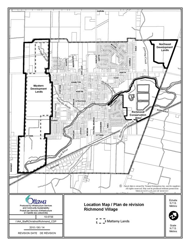
LAND USE (RICHMOND CDP) DOCUMENT
2
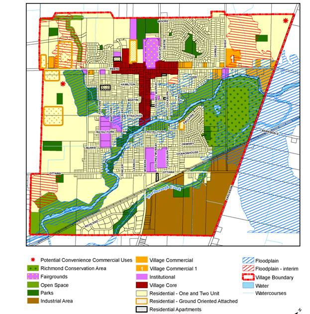
DEMONSTRATION PLAN –
MATTAMY’S NEIGHBOURHOOD CONCEPT PLAN DOCUMENT
4
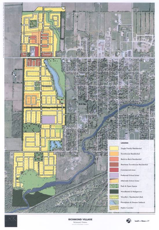
PARKS, OPEN SPACE AND PATHWAY PLAN DOCUMENT
6
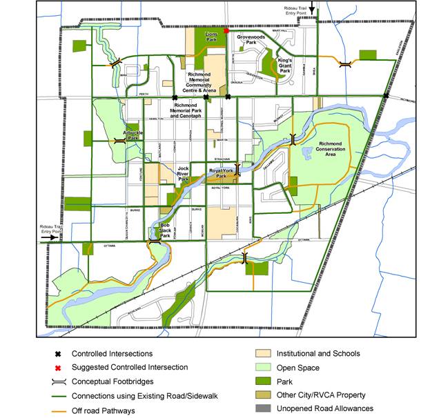
ENVIRONMENTAL CONSTRAINTS DOCUMENT
7
PROPOSED OFFICIAL PLAN AMENDMENT DOCUMENT
8
|
|

Amendment
to the
Official
Plan of the City of Ottawa
INDEX
THE STATEMENT OF COMPONENTS
PART A – THE PREAMBLE
Purpose
Location
Basis
PART B – THE AMENDMENT
Introduction
Details of the
Amendment
PART C – IMPLEMENTATION
Implementation
and Interpretation
APPENDIX A
Richmond Secondary Plan
PART A –
THE PREAMBLE
Purpose
The purpose of this
amendment is to establish a Secondary Plan for the Village of Richmond
replacing the existing Richmond provisions in Volume 2C of the Official Plan.
It provides a comprehensive planning framework for the village based on a
Community Design Plan that was prepared between 2008 and 2010. A village-wide
Master Servicing Study, an Environmental Management Plan, a Transportation
Master Plan and a Water Quality Assessment Study were also prepared as
background to the Community Design Plan and the Secondary Plan. These studies
are based on a 20-year plan for the village.
Location
This amendment applies to the lands presently included in the existing Village boundary of Richmond. The village of Richmond is located in the southwestern end of rural Ottawa, south of Kanata in Rideau-Goulbourn Ward. Richmond straddles the Jock River and is the second largest village in the City of Ottawa having 4,335 residents (2008 estimate).
Basis
The Community Design Plan
and the Secondary Plan were initiated partially in response to the growing
interest among residents and landowners about how the village should develop.
Further, the policies contained in the Ashton, Munster and Richmond Secondary
Plan 2003, stated that a servicing study was required when the village
population reached 4,500 people which it was close to achieving at the time
this Plan was adopted. The Plan is also
required to prepare for growth in the Western and Northeast Development Lands,
which were referred to as the Future Development Lands in the previous
Plan.
The planning process was a
collaborative and open one, involving community representatives,
landowners/developers, City representatives and the public at large. Community involvement was led by a Steering
Committee consisting mainly of local residents. The process was divided into
three stages: 1) visioning, 2) detailed analysis and 3) the final steps to
approval. In phase 1,
a community vision was established based on six principles, which became the
cornerstone for the Community Design Plan and this Secondary Plan.
·
Principle 1: Create
A Livable And Sustainable Community
·
Principle 2:
Protect And Enhance Richmond’s Historic Village Character
·
Principle 3:
Protect The Natural Environment And Incorporate Constraints Into The
Plan
·
Principle 4:
Expand And Maintain Transportation Infrastructure
·
Principle 5:
Create And Protect Open Space, Recreation And Community Services
·
Principle 6: Ensure Sustainability
Of Servicing (Groundwater, Wastewater and Stormwater Systems)
In stage two, the
studies mentioned in the purpose above were undertaken to ensure that enough
information was available to make the Plan. In addition, a detailed floodplain
analysis was undertaken in the Western Development Lands and an Environmental
Assessment process was followed for the servicing and transportation components
of the project.
In stage 3,
various issues were brought to the Steering Committee for discussion and all
the plans and studies were prepared in draft form for public circulation.
.
The public was
consulted at various points along the way including two Saturday morning
educational sessions and a four-day design workshop which were working sessions
that involved the public in selecting preferences and options. As well there
were a number of formal meetings that served to update the public (March 2008,
September 2008 and April, 2010). In addition, the 24 Steering Committee
meetings held during the process were open to the public and covered by the
local media.
This Amendment is consistent with the objectives of the Official Plan. A second, area-specific Official Plan Amendment, independent of this Amendment, was submitted by Mattamy Homes for the Western Development Lands. It is intended that the two amendments will be dealt with concurrently.
PART B – THE AMENDMENT
1. Introduction
All of this
part of this document entitled Part B – The Amendment consisting of the
following text and the attached Schedule A constitute Amendment No. __ to the
City of Ottawa Official Plan.
2. Details
a) The following changes are hereby made to the City
of Ottawa Official Plan:
i. Remove reference to “Richmond”
within the header of the document and tab of the “Ashton, Munster, Richmond”
contained in Volume 2C – Village Plans;
ii. Section 3.2.3, Section 3.3, Section
3.3.1, Section 3.3.2 and Table 3.3 and note are hereby deleted in their
entirety;
iii. Remove the following reference
“…Richmond,…” from Section 5.2.1 a) and Section 5.2.1 d);
iv. Section 5.2.1 f) is hereby amended by
removing “…sanitary and storm sewer and private/communal wells in Richmond;…”;
v. Section 5.2.1 h) is hereby amended
to delete the words “and the main streets of Richmond” and replace them with
words “and Village main streets”. The subsequent points are renumbered
accordingly;
vi. Section 5.2.1 k) is hereby amended
by removing “Mixed use development will be particularly encouraged on the main
streets of Richmond. Where appropriate, permitted residential uses with
frontage along the main streets in Richmond shall orient the front of the units
to McBean Street in Richmond.”;
vii. Section 5.2.2 (b) ii) is hereby
amended by removing “…; and to locations on the main streets of Richmond;…”;
viii. Section 5.2.2 (b) iv) is hereby deleted in its
entirety and subsequent points are renumbered;
ix. Section 5.2.2 (b) vii) is hereby
amended by removing “…, but will not exceed 15 metres in Richmond.”;
x. Section 5.2.3 is deleted in its
entirety;
xi. Section 5.4.3 is deleted in its
entirety;
xii. In Section 6.2.1.3 a) remove the sentence
“Such clusters are permitted in Richmond.”;
xiii. Section 6.2.1.3 a) iii. is hereby
deleted in its entirety and subsequent points are renumbered;
xiv. Section 6.2.3, Section 6.3.3 and
10.4.3 are hereby deleted in their entirety;
xv. Remove all references to “Schedule
A2 and” from Sections 10.4 and 10.4.2;
xvi. Section 10.4 a) is hereby deleted in
its entirety and subsequent points are renumbered;
xvii. Remove the Township of Goulbourn
Official Plan Schedule A2;
b) The City Official Plan – Volume 2C
is hereby further amended by:
i.
adding to the table of contents the Secondary Plan for
Richmond, the following title:
“Richmond Secondary Plan”
ii.
Adding as a new section next after the last approved
Secondary Plan in Volume 2C of the City’s Official Plan the “Richmond Secondary
Plan” attached at Appendix A to this amendment.
PART C – IMPLEMENTATION
The relevant
policies of Section 5 - Implementation of the City’s Official Plan apply to
this amendment and the attached Richmond Secondary Plan.
APPENDIX A - Richmond Secondary Plan
1.0 Introduction
Richmond
was founded in 1818 and is the oldest community in the former Township of
Goulbourn. Historically, growth in Richmond has been modest with a population
that now approaches 4,500 people. Former
plans included 210 hectares of land set aside for future growth. This Plan
provides guidance for the development of these lands and the redevelopment of
older areas of the village over time in a manner consistent with the community
vision. The Village of Richmond Secondary Plan (hereafter referred to as ‘the
Plan’ or the “Secondary Plan”) should be read in conjunction with Volume 1 of
the Official Plan and the Village of Richmond Community Design Plan (hereafter
referred to as ‘the Community Design Plan’).
2.0 Managing
Growth
This Plan
is based on a twenty-year planning period, from 2010 to 2030. The Master
Servicing Study indicated that, at the time this Plan was adopted, the village
had reached its development capacity based on the limitations of existing
sanitary services. With the upgrades to these services as proposed in the
Master Servicing Study, the residential capacity of the village is planned to
increase from approximately 1,550 dwelling units to between 4,400 to 5,500
units (including existing units). In the
Western Development Lands the expected range is between 1,800 to 2,300 dwelling
units at build-out based on stages described in Section 8 of the Community
Design Plan. In most of the village,
water services will continue to be provided, as they are now: a combination of
private and communal wells. In the Western Development Lands water will be
piped from communal wells that will be owned and managed by the City. The
communal well system will be sized to provide water to the entire village as a
contingency for the future. To ensure that new development does not occur
before the required services are available, holding provisions in the zoning
by-law may be applied to vacant land.
Policies
Water
1. Development in the Western Development Lands shall be on the basis of public communal well services. Development in the Northeast Development Lands, the Industrial Lands and the remainder of the village shall be based on private or communal wells unless it is deemed necessary to convert the village to a communal well system.
Wastewater
2. All development
in Richmond shall be connected to the central wastewater collection system. No development
shall be permitted until the wastewater system can provide the capacity in
accordance with the Master Servicing Study. Notwithstanding the above, until
piped services are extended south of the railroad tracks, private services may
be permitted in the Industrial Lands to the satisfaction of the City.
3. Existing wastewater infrastructure services shall be upgraded over time to provide the required capacity for the full development of the Village of Richmond. Upon submission of a development proposal, the proponent shall be required to demonstrate that capacity exists to service the development.
Transportation
4.
Upon submission of a development proposal, the City will evaluate the
transportation design against the Community Design Plan and the Transportation
Master Plan.
5.
While no additional road capacity is required to serve growth over the
planning period, specific road improvement projects and the addition of new
collector roads and pathways are required in the village as identified on
Schedule C to the Community Design Plan.
3.0 Land Use
The land use policies in the Plan guide future
development in the village of Richmond through the following land use
designations with guidance from the Community Design Plan.
Policies
1. The land use
designations are shown on Schedule A – Land Use, which forms part of this plan.
2. Upon submission
of a development proposal, the proponent will be required to demonstrate that:
a) It is in
accordance with the Servicing Policies of this Plan and the Official Plan.
b) Through the
appropriate design analysis, development addresses the provisions of the Village
Design Guidelines and Demonstration Plans as contained in the Community Design
Plan.
3. The City will
evaluate a proposal to change the designation of land from one category to
another against its ability to meet the provisions in the following sections of
the Community Design Plan:
a) Section 1.4
Visionary Principles
b) Section 1.5
Liveable Community Initiatives
c) Section 4 Land
Use
4. In keeping with Richmond’s village
character, the proponent of development shall provide a minimum of one tree in
the road right-of-way of every new proposed ground-oriented dwelling and on
both sides of all arterial and collector roads. If it has been determined that
the soils cannot accommodate street trees in the arrangement proposed, then the
road right-of-way or the building setbacks shall be increased so that trees can
be provided.
3.1 The Village Core
The Village Core is the heart of Richmond. It reflects the village’s history, rural
roots, small-town character and architectural heritage. In earlier times, McBean Street was once the
main commercial street for the village and the Richmond Agricultural
Fairgrounds on Perth Street was on the outskirts of the Village. These areas are to become the central place
for the Village. The Village Core is envisioned to be a vibrant,
pedestrian-oriented commercial area, comprised of smaller-scale buildings,
which are readily accessible to residents, by a variety of means besides motor
vehicles. The largest retail site, the
“Richmond Plaza” at the western end of the Village Core, is an area that needs
revitalization to complement the mixed-use vision for the Village Core.
Policies
1. Permitted uses on
lands designated Village Core include: retail, service commercial, office uses,
parks and small institutional uses including a primary school.
2. Residential uses
are also permitted on lands designated Village Core and include: existing
dwellings, apartments, residential in combination with a permitted
non-residential use, multiple dwellings and retirement homes.
3. Vehicle-oriented
uses such as vehicle sales, rental and service uses and drive-through
facilities that legally existed on the date of the adoption of the Plan may
continue however no new uses of this kind shall be permitted.
4. A maximum
four-storey and a minimum two-storey height limit shall be required to define
the edge of the street and to help create a village-style streetscape.
5. The City will
evaluate development proposals in the Village Core against their ability to
meet City Design Guidelines and the Community Design Plan. It is envisioned
that the Village Core will evolve into a mixed-use street with a variety of
village-style buildings, storefronts, signage and pedestrian amenities.
6. Reduced parking
requirements shall be established to encourage businesses to locate in existing
buildings and to help revitalize the Core.
7.
On-site parking shall be located to the side of or behind
buildings. If it is located at the side,
the parking should be no closer to the street than the front of the building
and landscaping should be used to help buffer parking areas from the sidewalk
and abutting properties.
3.2 Village Commercial
Lands designated as Village
Commercial provide places outside the Village Core for retail and service
commercial uses. This designation is limited in area in order to focus
commercial uses in the Village Core. Development
in Village Commercial areas shall balance the needs of
pedestrians and cyclists with the needs of automobiles and other vehicles. Any development in this designation shall
have regard for all relevant City approved Urban Design Guidelines including
those identified for Rural Villages.
Policies
1. Uses permitted on
lands designated Village Commercial include: retail and service commercial uses,
institutional uses, car-oriented uses and facilities that serve residents,
visitors and the surrounding rural community.
2. The City will
evaluate development proposals in the Village Commercial designation against
their ability to meet City Design Guidelines and the Community Design Plan.
High quality design is expected for all properties in this designation and
building and landscape design shall be reflective of the village-style
character.
3. Within the
Village Commercial designation, the maximum building height limit should be
three-storeys.
4. In order to reinforce a pedestrian environment, development proposals should not locate parking directly adjacent to Perth Street. Where it is determined by the City that parking is appropriate, it may be permitted and shall be done in the following arrangement (from the building to the sidewalk): a wide pedestrian space that is frequently connected to the sidewalk, a vehicular passageway, one-tier of parking and a landscaped space designed to screen the lower portion of the vehicles from the sidewalk.
3.2.1 Village Commercial 1
Lands
designated as Village Commercial 1 provide a location for large-lot retail and
service commercial uses not readily available elsewhere in the village. The
Market Evaluation (February 2010) prepared by Malone Given Parsons in support
of a development proposal for these lands establishes that the village
currently has sufficient demand for this type of use. The Evaluation also
concludes that the commercial development of the designated site can
successfully coexist with the development of the Village Core. There will also
be positive benefits for the village given that more residents who shop outside
the village will shop locally. The
reason this Village Commercial site is treated separately from other Village
Commercial designations is to limit the size of the stores and to add specific
policy direction for this large site.
Policies
In addition to the policies contained in the Village Commercial designation, the following shall apply:
1. The total maximum gross floor area permitted on the site shall not exceed 7,000m2, and no single individual occupancy shall exceed 2,790m2.
2. The City will evaluate any development containing a proposed
drive-through facility against its ability to meet City Design Guidelines for
Drive-Through Facilities and the Community Design Plan. Drive through lanes
shall not be permitted in front of street oriented buildings along Perth
Street.
3. Buildings located near Perth Street shall functionally front the
street. Building elevations facing Perth Street are to be aesthetically
pleasing and contain entrance doors and windows (clear glazing) with a minimum
window target of 50% along the length of the façade.
4. Street-oriented
buildings shall be encouraged along the Perth Street frontage with a target of
50% built form along the developable frontage at build-out.
1. Upon submission of a development application in the Village
Commercial 1 designation, the proponent will demonstrate how they meet the
objectives of this Plan and the Community Design Plan through the submission of
a design brief.
2. Servicing of these lands will be on the basis of the recommendations
contained in the Master Servicing Study for the Village of Richmond.
3.3 Residential
Residential areas are envisioned to
be village-style neighbourhoods that fit well with older parts of the
community. These areas will provide a variety of housing styles and a wide
range of community services so that residents can age in place in the same
community if they so choose. Affordable housing is also needed so that the
village offers housing options for people of all ages and incomes.
Policies
1.
Uses permitted on all lands
designated Residential include: secondary dwelling units, group homes, rooming
houses, shelter accommodation, retirement homes, care facilities, garden
suites, home-based businesses, public utilities, open space and parks. Vacant residential lands that are currently
being used for agricultural purposes may continue to be used for this purpose.
2. The following uses may also be permitted on all lands designated
Residential subject to a zoning amendment.
a) Garden suites
based on the ability of the site to accommodate the use
b) Small
institutional uses such as a church and daycare located on an arterial or
collector road based on a review to confirm there will be no significant
surrounding impacts
c) Primary schools
based on the following:
· The site is a
suitable size (2-3 ha) and configuration (generally rectangular)
· It is located on
two street frontages (collector/local road or collector/collector)
· As many children
as possible are within walking distance
· Those walking do
not have to cross what is perceived to be an unsafe or hazardous crossing
d) One or two small
convenience commercial uses (e.g. coffee shop, corner store) that serve the
day-to-day needs of the surrounding neighbourhood as shown at the general
location(s) identified on Schedule A.
3.3.1 Residential – One and
Two-Units
The Residential – One and Two-Unit
designation is the predominant residential designation in the village. It
provides for a range of ground-oriented, low-density residential and associated
uses including detached and semi-detached dwellings.
Policies
1.
Uses permitted on lands designated
Residential – One and Two-Units include: detached and semi-detached dwellings,
duplexes, bed and breakfast, home-based businesses, and retirement homes -
converted.
2. A limited number
of multiple attached dwellings not including apartments or stacked townhouses
may be permitted by zoning amendment at the following locations, as long as the
immediate area is surrounded by a significant band of detached and
semi-detached dwellings.
a) On an arterial or
collector road
b) Abutting a park
or designated open space
c) At the edge of a
neighbourhood
3. The maximum building
height shall be approximately three and a half storeys.
4.
Upon submission of a development application in the
Residential – One and Two-Unit designation, the proponent will demonstrate
conformance to Schedule B – Parks, Open Space and Pathways Plan in the Community Design Plan.
5. The City will evaluate a development proposal in the Residential – One
and Two-Unit designation against its ability to meet City Design Guidelines and
the Community Design Plan.
6. New plans of
subdivision will use the historical grid pattern for streets and will ensure
equitable access to parks and other open spaces as required by the Official
Plan.
3.3.2 Residential – Ground-Oriented Attached
The Residential Ground-Oriented
Attached designation provides for a range of ground-oriented, higher density
housing forms to provide a greater diversity of accommodation that will serve a
variety of age groups and income levels close to uses and services that meet
their needs.
Policies
1. Uses permitted on lands designated Residential – Ground Oriented
Attached include: triplexes and ground-oriented attached dwellings containing 6
units or less. A limited number of detached, duplex, and semi-detached
dwellings may be permitted as long as 50% of the area of the designation
remains for attached dwellings as defined above.
2.
The maximum building height should be three and a half
storeys.
3.
The City will evaluate a development
proposal in the Residential – Ground-Oriented Attached designation against its
ability to meet City Design Guidelines and Community Design Plan.
4. With the
exception of private driveways, on-site parking should be located to the side
or behind a building so that the front elevation can be close to the
street. If it is located at the side,
the parking area should be visually screened from the sidewalk and from
abutting neighbours.
3.3.3 Residential – Apartments
The Residential - Apartments
designation provides for more intensive, non-ground-oriented residential uses
such as stacked townhouses and apartments.
Policies
1. Uses permitted on
lands designated Residential – Apartments include: stacked townhouses and
apartments.
2. The City will evaluate a development proposal in the Residential –
Apartment designation against its ability to meet City Design Guidelines and
Community Design Plan.
1. The maximum
building height should be four storeys.
2.
A zoning amendment and an amendment to the Community Design
Plan will be required to create new residential apartment or stacked townhouse sites.
An amendment to the Official Plan is not required unless the height of the
proposed building is significantly greater than the maximum permitted. The following criteria shall be used to assess these applications:
a)
Located on arterial roads or
b)
Located near a park
c)
Compatible with the surrounding
community which may be achieved through building transitions and compliance
with a maximum density of approximately 99 units/ha
d)
Of high-quality design based on the
Design Guidelines in the Plan
3.3.4 Western Development Lands
The policies in this section deal
with lands in the west of the village that were identified for future
development. The Demonstration Plan for these lands, as shown in this Plan,
defines the boundary of the Western Development Lands and will be considered in
the development of these lands. This Demonstration Plan was derived from a three-day design workshop hosted
by Mattamy Homes in December 2008 that focused on how best to develop these
lands. The workshop was a collaborative effort between LRK, Mattamy, the City
and the community. Development will primarily consist of
detached dwellings, townhouses, parks, open spaces, a school and a pathway
system.
Principles
of Development
In
addition to the policies contained in the Residential and other designations of
this Plan, the following shall apply to the Western Development Lands:
1.
The Western Development Lands shall
comply with the density and unit mix provisions contained in the chart below:
|
Dwelling
Type |
Max Density Units/Net Ha |
Unit Mix (% of Total) |
|
One
& Two Units Large Lots |
17 |
2–7% Minimum |
|
One
and Two Units Small Lots |
30 |
58–78% Maximum |
|
Townhouses |
45 |
20–35% Minimum |
|
Townhouses
with Rear Lanes |
80 |
|
|
Back-to-Back
Townhouses |
99 |
2.
Development phasing shall be in
accordance with the Infrastructure Phasing Plan as contained in Section 8 of
the Community Design Plan.
3.
The City will evaluate a development
proposal in the Western Development Lands against its ability to meet the Demonstration
Plan as displayed in the Community Design Plan.
Watercourse setbacks
4. Setbacks
for the Jock River and the permanent flowing sections of the Moore Branch
(Sections 1, 2 and 3 lower) and the VanGaal/Arbuckle Drain shall be in
accordance with watercourse setback policy in the Official Plan. In addition,
the Jock River setback will also be based on the requirements of an EIS to be
submitted with the plan of subdivision. The setbacks will be confirmed to the
satisfaction of the City in consultation with the RVCA given the proposal
to locate the stormwater pond within
the floodplain. The pond must be located
a minimum of 30 m from top of bank.
5. The
following watercourse setbacks shall apply to the Moore Tributary. The setbacks for sections 3-5 are contingent on the outcome of the
Arbuckle and Moore municipal drain petition processes.
|
Moore
Tributary |
Setback |
|
Section
3 (Upper) |
30m
from top of bank |
|
Section
4 |
30m
from top of bank |
|
Sections
5-8 |
15m
from top of bank |
6. The interim floodplain area north of
Perth Street shown on Schedule A dictates that prior to development being
permitted behind the 30 m berm from the Van Gaal Drain, the proponent will have
to undertake sufficient works to demonstrate that:
·
Existing
flood elevations are matched
·
There
will be no increases in flood levels on adjacent properties and
·
A
30 m setback is maintained due to the watercourse remaining a direct fishery.
3.3.5 Northeast Development Lands
The
policies in this section deal with lands in the northeast of the village. The
Demonstration Plan for these lands, as shown in this Plan, defines the boundary
of the Northeast Development Lands and will be considered in the development of
these lands.
Principles
of Development
In addition to the policies contained in the Residential designations of this Plan, the following shall apply to the Northeast Development Lands:
1. The maximum density for one and two unit - large lot residential as
shown on the table in section 3.3.4 shall apply to all plans of subdivision on
these lands. If greater densities or a wider range of unit mix are desired, the
proponent shall be required to submit a concurrent CDP/Zoning amendment to
determine which parts of the table shall apply to the satisfaction of the City.
3.3.6 The Floodplain
The floodplain is a
limitation on the underlying land use designation in that no new development is
permitted. Vacant land in the floodplain has generally been designated as Open Space
and developed land has generally been designated to match the existing use(s).
Principles of
Development
1. The policies in
section 4.8.1 of the City’s Official Plan shall apply to all land identified as
floodplain as shown on Schedule A of this Plan.
2. The floodplain is
subject to change by the Rideau Valley Conservation Authority. Any changes
approved by the RVCA will not require an amendment to this Plan.
3. Four floodplain areas are designated as Interim Floodplain on Schedule
A. This indicates that the Rideau Valley Conservation Authority has either a)
approved a change in principle or b) received an application to modify the
floodplain in these areas. The reference to interim on Schedule A means that if
and when the RVCA changes their floodplain mapping for these lands, then
development can proceed based on the underlying land use designations and in
accordance with the Demonstration Plans without amending the floodplain as
shown on Schedule A to the Community Design Plan or the Secondary Plan.
3.4 Institutional
The Institutional land use
designation accommodates a range of community and emergency uses that serve the
needs of Richmond area residents and visitors.
This designation applies to the larger institutional uses in the
village. Other smaller scale institutional uses including a primary school may
be located in other designations such as the Village Core or the Residential
designations.
Policies
1.
Uses permitted on lands designated
institutional include: a range of public uses such as a library, school, fire
station, arena, community facilities used by the public, cemetery, church,
community garden, museum, retirement/residential care facility and other
associated uses.
2.
New institutional uses should be
located in such a way as to provide adequate buffering to any nearby
residential uses. Large institutional uses such as a high school will require
an amendment to the Secondary Plan and the Community Design Plan.
3.5 The Richmond Fairgrounds
The Richmond Agricultural Society
runs the Richmond Fairgrounds located at the northwest corner of Perth Street
and Huntley Road. These lands are home to the annual Richmond Fair, which is a
major annual attraction held in the third weekend of September. The Fair is an
event that has put the village on the map throughout Eastern Ontario, being one
of the largest fairs of its kind in the area. It is also one of the oldest; the
first Richmond Fair being held in 1844.
The Fair provides “an opportunity for families to enjoy viewing the best
of their neighbour's kitchens, crops, livestock and machinery. It also plays an
important role in exposing the general public to agricultural practices. As
people move away from the farm, the Fair is a way to remind them about where
their food comes from.” (Agricultural Society website) These
lands contain the Richmond Curling Club, the Dining Hall, two large
agricultural buildings and other smaller accessory buildings. The Richmond
Fairgrounds designation is intended to reflect the roots of the local farming
community and to provide only those uses needed to ensure the long-term
viability of the Richmond Fair.
Policies
1. Uses permitted on
lands designated Richmond fairgrounds include: a fairground, a recreation and
athletic facility and other ancillary uses to a fairground, a community centre
and a recreational facility.
2. Future changes to
the Richmond Agricultural Society lands should consider the following:
a) Improvements to
the pedestrian environment along Perth Street
b) Greater pedestrian
access between Perth Street and the sports facilities to the north
3.6 Industrial Lands
The Industrial Lands provide an opportunity for industrial
and employment-generating uses that require large parcels of land and that are
not always compatible with residential uses.
Policies
1. Uses permitted on
lands designated Industrial Lands include: light industrial uses, office,
printing plant, service and repair shop, small batch brewery, warehouse and
heavy equipment and vehicle sales, rental and servicing, research, technology,
nurseries, greenhouses, catering, places of assembly, broadcasting and
training.
2.
The maximum building height should be equivalent to four
storeys.
3. The City will evaluate a development proposal in the Industrial Lands
designation against its ability to meet the Design Guidelines and the Community
Design Plan with particular attention to the Demonstration Plan. As these lands
develop, there may be adjustments made, but the intent of the Demonstration
Plan should be maintained.
4. The Industrial
Lands shall be serviced based on the Master Servicing Study to ensure that
there is a logical and coordinated approach to development.
5. For buildings
that abut McBean Street and Eagleson Road, front and side building elevations
are to be aesthetically pleasing and have primary doors and real windows (with
a target of 50% window coverage) oriented towards the street.
6. Adequate
buffering including landscaping and screening will be provided between uses in
the Industrial Area to ensure that storage areas and parking areas are screened
from adjacent properties and from McBean Street.
3.7 Parks
Lands
that are designated Parks are intended to be used for park and recreational
purposes and normally provide a range of publicly accessible facilities for
residents and visitors. Aside from
existing municipal parks and those planned for the future, there are a number
of unopened road right-of-ways that end at the Jock River. By designating these lands as “Park”, greater
public access can be provided along the length of the Jock River as envisioned
by residents in the vision for Richmond.
Policies
1.
Uses permitted on lands designated
parks include: a park, recreational and athletic facility, environmental
preserve and an education area.
2. Parks will be developed in consultation with local residents and parks
planning staff and
should be based on the following:
·
Pedestrian
connections should be provided to sidewalks and pathways
·
The
park should be exposed to local streets with a minimum of two street frontages
·
Crime
Prevention through Environmental Design (CPTED) should be considered in the
design of the park
·
The
park should not be located immediately adjacent to school properties but may be
associated with other community facilities or infrastructure
·
The
park will not be used as part of, or associated with, the function of the
stormwater management system.
3.
The Parks, Open Space and Pathways
Plan, as shown on Schedule B of the Community Design Plan, should be consulted
to ensure a high degree of connectivity between parks and the rest of the
village.
4.
New parks will be required in the
Western and Northeast Development Lands and in the Industrial lands as shown on
Schedule A. Their specific locations will be determined through the development
review process.
3.8 Open Space
The Open Space designation applies to
natural lands not used for park purposes or that are constrained by
floodplains. Lands in this designation link the parks and the shores of the
Jock River together into an open space network that contributes to the quality
of life for residents of the village.
Policies
1.
Uses permitted on lands designated
Open Space include: passive recreation, community garden, environmental preserve
and education area. Agricultural use limited to the growing of crops shall be
permitted but not within 30 m of the Jock River.
2.
The boundaries of the Open Space
designation are based on current mapping information. The precise boundary of
open space will be defined by the zoning by-law. As a result, when more
information is obtained, minor adjustments may be made to the boundary by
zoning amendment only. Major changes or the removal of open space will require
an amendment to the Secondary Plan.
3.
For land in private ownership that is
designated Open Space, access to these lands is not permitted without the
consent of the property owner.
4.
Multi-use pathways will be
incorporated near the Jock River or other waterways through the development
review process.
3.9 The Richmond Conservation
Area
The Richmond Conservation Area designation accommodates a
variety of outdoor leisure and environmental uses that allow the area to
continue to be used as one of the two major environmental features within the
village (the other being the Jock River). The Area will be used by the local
birding community and serve as part of the Rideau Trail, which is a part of the
Trans-Canada Trail. In 2006, the Rideau
Valley Conservation Authority initiated a discussion with the community about
management strategies for the Area. Although many good ideas were developed, a
management plan for the area was never finalized. As part of the preparation of this Plan
(2010), the management plan was revisited and included site visits to confirm
the existing conditions recorded in the 2006 management plan and meetings with
conservation authority staff on the likelihood of implementing the draft
recommendations. As part of the Community Design Plan process, City staff
received public comments on the Jock River and the Conservation Area, which
have been incorporated into this Plan.
Policies
1. Uses permitted on
lands designated Richmond Conservation Area include: passive
recreation, community gardens, environmental preserves, education areas, parks, outdoor
recreation facilities and utilities such as a wastewater lagoon facility.
2. The City will explore options for
capital improvements and infrastructure funding for the Richmond Conservation
Area and public lands along the Jock River.
4.0 Natural Heritage Systems and
Heritage Resources
The City has prepared an Environmental
Management Plan (EMP) for the village of Richmond to support this Community
Design Plan. The EMP identifies natural features such as the Jock River,
Marlborough Creek and their tributaries and terrestrial resources such as the
Marlborough Forest and Richmond Conservation Area, local woodlots and
hedgerows. Through the identification and evaluation of these features, new
development can be directed away from areas that are significant or sensitive
to impacts. The environmental features map is shown on Schedule D of the
Community Design Plan.
Buildings
of heritage interest and the layout of the community are important components
from the past that should be part of the future. Therefore development shall
not only be compatible with what remains but shall enhance it.
Policies
1. In relation to the protection of
natural heritage systems, the provisions contained in the Community Design Plan
and the Environmental Management Plan shall guide development.
2. When considering a development
application, Council will be guided by the following Official Plan policies and
considerations:
a) Development is not permitted within
the Marlborough Forest. Any other proposed development within 120m of the
significant woodland identified on Annex 14 of the Official Plan would require
an Environmental Impact Statement (EIS). Section 4.7.8 of the Official Plan
describes the EIS and its scope.
b) Watercourse setbacks will be based
on section 4.7.3 of the Official Plan. The minimum setback shall be determined
based on technical studies completed to support all development applications.
3.
The buildings of heritage interest, as identified in Appendix 3 of the
Community Design Plan, shall be added to the City of Ottawa’s Heritage
Reference List and Registry to ensure that demolitions and building alterations
are monitored. The City may add more buildings over time.
4. To help conserve buildings of heritage interest, the Heritage Resources policies (Section 5) and the Design Guidelines (Section 7) of the Community Design Plan shall guide development.
5.0 Implementation
Implementation and interpretation of
this Amendment shall be in accordance with the City of Ottawa’s Official Plan policies
and the implementation policies as contained in the Community Design Plan.
1. The Community Design Plan shall be adopted by City Council as the policy direction for the village. A portion of Section 3.0 (Managing Growth), most of Section 4.0 (Land Use) and Schedule A of the Community Design Plan will be adopted as a Secondary Plan.
2. Unless otherwise specified, an amendment to the Secondary Plan (OPA) shall be required for any substantive change including a change to the water and wastewater policies, a change from one major land use category to another including the addition of a new Residential Apartment designation involving a building that is significantly higher than the permitted building height and the elimination of a park designation. In these instances the provisions in the Community Design Plan will automatically be changed with the OPA.
3. An amendment to the Community Design Plan (as a concurrent application to a zoning or subdivision application) shall be required for any substantive change to a policy or Schedule contained in the Community Design Plan that is not contained in the Secondary Plan as well as the addition of a new Residential – Ground Oriented Attached designation or a new Residential – Apartment designation where the proposed building is not significantly higher than the permitted height or the substantive re-location of a park.
4. Minor, non-substantive changes to the CDP or interpretations to the village design guidelines and demonstration plans shall be made at the discretion of the Director of Planning and Infrastructure Approvals. In these cases, subdivision, site plan and zoning approval by the City constitute approval of the change or interpretation of the provisions of the CDP.
SCHEDULE A - LAND USE
ZONING DETAILS DOCUMENT
9
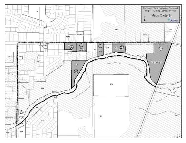
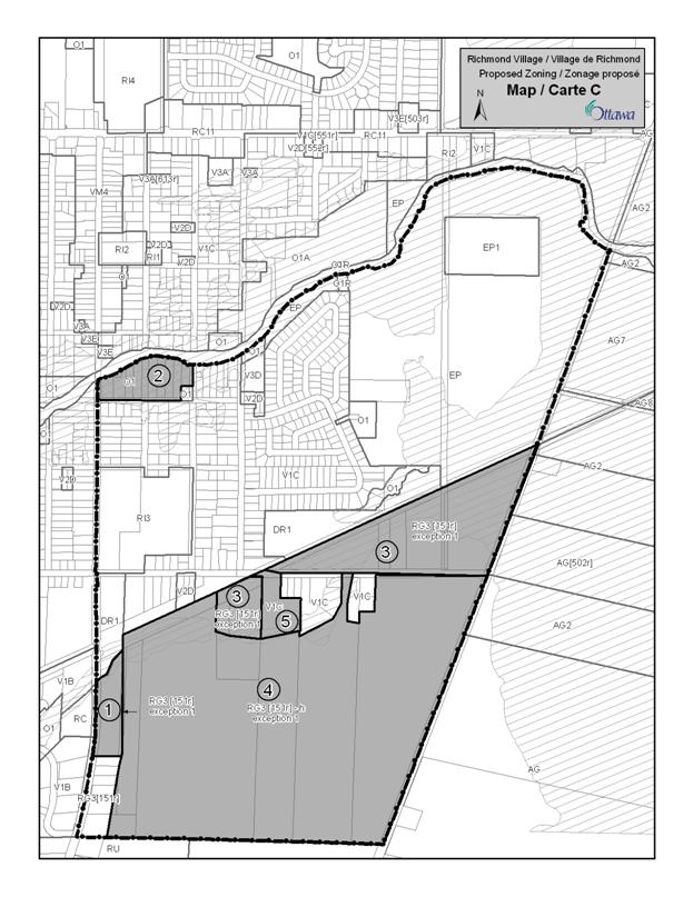
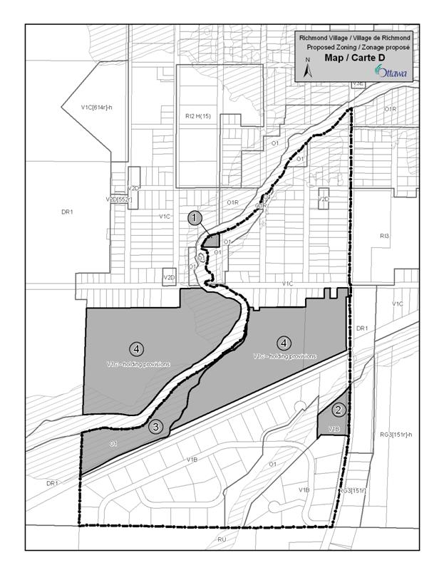
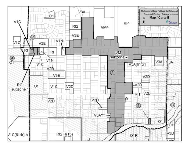
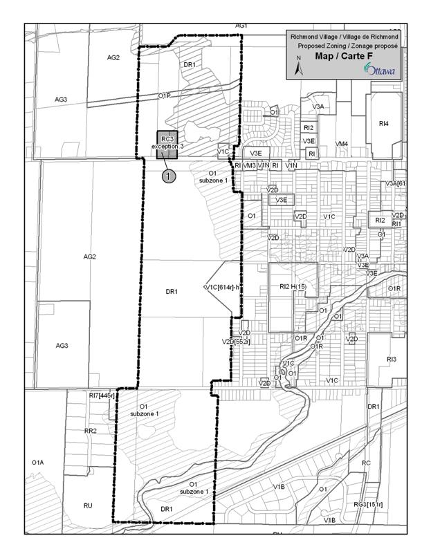
|
Richmond Village
Community Design Plan TABLE 1 - Existing Zoning
|
|
|
Zoning |
Description |
|
DR1 (Village Development Reserve) |
Permitted
uses
Include agricultural use, community garden, environmental preserve and education area and one detached dwelling Regulations
No min. lot area or min. lot width requirements. Max. height: 11 m. |
|
EP (Environmental Protection) |
Permitted
uses
Only environmental preserve and education area, forestry operation Regulations
No min. lot width, no min. lot area, max. height: 11 m. |
EP1 (Environmental
Protection) subzone
|
See EP description. Permitted uses
EP1 also permits utility installation. |
|
O1 (Parks and Open Space) |
Permitted
uses
Community garden, environmental preserve and education area, park Regulations
No min. lot width, no min. lot area, max. height: 11 m. |
|
O1A (Parks and Open Space) subzone |
Permitted
uses
Community garden, environmental preserve and education area, park and golf course Regulations
No min. lot width, no min. lot area, max. height: 11 m. |
|
O1Q (Parks and Open Space) subzone |
Permitted
uses
The only permitted use is park limited to open space only. No buildings are permitted and only structures (signage, standpipe or other similar structure are permitted) |
|
O1R (Parks and Open Space) subzone |
Permitted
uses
Only permitted uses: environmental preserve and education area, forestry operation Regulations
No min. lot area, no min. lot width, max. height: 11 m. |
|
RC (Rural Commercial) |
Permitted
uses
Include amusement centre, amusement park, animal care establishment and restaurant Regulations
Min. lot area 4000 sq.m., min. lot width 30 m., max. height 11 m. |
|
RC2 (Rural Commercial) subzone |
Permitted
uses
Include all uses permitted in the RC parent zone such as amusement centre, amusement park, animal care establishment and restaurant Regulations
Min. lot area 2000 sq.m., min. lot width 30 m. max. height 11 m. |
|
RC3 (Rural Commercial) subzone |
Permitted
uses
Include all uses permitted in the RC parent zone such as centre, amusement park, animal care establishment and restaurant Regulations
Min. lot area 8000 m.sq., min. lot width 60 m., max. height: 11 m. |
|
RC11 (Rural Commercial) subzone |
Permitted
uses
Include amusement centre, automobile dealership, convenience store, funeral home, heavy equipment and vehicle sales, rental and servicing Regulations
Min. lot area 1350 m. sq., min. lot width 20 m., max. height 11 m. |
RG3 [151r] (Rural General
Industrial)
|
Permitted uses
Include animal hospital, automobile body shop, heavy equipment and vehicle sales, rental and servicing, retail store, warehouse, waste processing and transfer facility and some conditional permitted uses. Regulations
Min. lot area: 2000 sq.m., min. lot width: 30 m. Exception
Exception 151r also permits office and recreational and athletic facility, allows min. front yard 15 m., min. rear yard not abutting railroad right-of-way of 8 m., max. lot coverage 35%, no max. height limit |
|
RG3 [151r]-h (Rural General Industrial) |
See RG3[151r] description above The holding symbol (-h) may only be removed once the City has approved an overall plan for servicing and street layout and any necessary subdivision plans are submitted and approved. |
|
RI2 (Rural Institutional) subzone |
Permitted
uses
Include retail food store limited to a farmers’ market, cemetery, community health and resource centre, library, place of worship, retail food store, retirement home, school Regulations
Min. lot area 4000 m. sq., min. lot width 60 m. max. principal building height 12 m. |
V1B (Village Residential
First Density Zone)
|
Permitted uses
Include bed and breakfast, community garden, detached dwelling, home-based business Regulations
Min. lot area is 8000 m.sq. with a min. lot width of 50 m. |
|
V1C (Village Residential First Density Zone) |
Permitted
uses
Include bed and breakfast, community garden, detached dwelling, home-based business Regulations
Min. lot area 600 m. sq., min. lot width 45 m. |
|
VM4
(Village Mixed-Use Zone) |
Permitted
uses
Include amusement centre, automobile rental establishment, retail store, retail food store, convenience store, dwelling unit, marine facility, parking lot, shopping centre, personal service business and retirement home. Regulations
Min. lot size 600 m.sq,. min. lot width 18 m. |
|
Richmond Village Community
Design Plan TABLE 2 DRAFT Proposed Zoning
Categories |
|
|
Zoning |
Description |
|
O1 Parks and Open Space Zone |
The purpose of the zone is to permit parks, open space and related compatible uses. The following uses are permitted: - community garden and - park |
|
O1 [310r] |
In addition to the uses permitted in the O1 zone, agricultural use is also permitted. |
|
O1Q |
The following use is only permitted: - park No buildings are permitted and only structures such as boat launch, dock, walkway, stairs, fence, retaining wall, information signage, standpipe or other similar structure providing for local access and service are permitted. |
|
O1R exception |
In addition to the uses permitted in the O1R subzone, a park is also permitted. |
|
RC11 exception 1 |
The only permitted uses are: - detached dwelling - office - personal service business - medical facility - service and repair shop |
|
RC11 exception 2 (MacEwan Gas and Drummonds) |
The only permitted uses are: - amusement centre - artist studio - automobile rental establishment - automobile service station - bed and breakfast establishment - catering establishment - convenience store - drive-through facility - heavy equipment and vehicle sales, rental and servicing (tractors/farm equipment) - gas bar - medical facility - office - personal service business - restaurant - fast food |
|
RC2 exception 3 (John Deere - East of Shea and located in floodplain) |
The only permitted uses are: - automobile rental establishment - automobile dealership - automobile service station - heavy equipment and vehicle sales, rental and servicing - retail store limited to the sale of agricultural, construction, gardening or landscaping-related products, equipment or supplies |
|
RC exception 4 |
The only permitted uses are: - agricultural use - retail store limited to the sale of agricultural, construction, garden or landscaping-related products, equipment or supplies |
|
RC3 exception 3 Home Hardware and lot to the east |
Only the following uses are permitted: - retail store limited to sale of agricultural, construction, gardening or landscaping-related products, equipment or supplies - animal care establishment - animal hospital - detached dwelling |
|
RG3 [151r]-h and RG3 [151r], exception 1 |
The following uses are also permitted in addition to the uses allowed in the RG3 [151r]-h subzone: - research and development centre - technology industry - agricultural use limited to a nursery, greenhouse or market garden - broadcasting station - catering establishment - place of assembly - production studio - training centre
The following uses are prohibited: - convenience store - drive-through facility - restaurant The following phrase “…and street layout…” shall be removed from the holding provision. |
|
VM subzone x |
The following shall apply to the new subzone: · Prohibited uses shall include a cemetery and an automobile rental establishment · Prohibited uses shall also include a gas bar and an automobile service station except those existing on the date of the passing of this By-law · 50% of the lot width, within 3 metres of the front lot line, must be occupied by building walls · Parking shall not be required for the first 100 m2 of gross floor area. |
|
TABLE 3 DRAFT Zoning
Recommendations |
||
|
Ref. |
Existing Zoning |
Recommendation |
MAP A
|
||
|
1. |
13 Grovewood Lane
Grovewoods Park V1C |
O1 zone |
|
2. |
5945, 5947, 5953, 5957, 5961, unaddressed Perth
Street properties, RC11 |
V1C |
|
3. |
5967 Perth Street
(Seabrooke Heating & Air Conditioning), 5971 Perth Street
(computer sales) RC11 and V1C |
|
|
4. |
5925 Perth Street (McEwan Gas) and 2790 Eagleson
Road (Drummond Gas)
RC11 and RC |
RC11 exception 2 |
|
5. |
5831 Perth Street (John Deere)
RC2 |
RC2 exception 3 |
MAP B
|
||
|
1. |
3440 Eagleson Road (Richmond Nursery)
DR1
|
RC exception 4 |
|
2. |
5882 Perth Street
DR1
|
V1C |
|
3. |
5906 Perth Street
RI2
|
V1C |
|
4. |
5940 Perth Street (City of Ottawa)
EP
|
O1 |
|
5. |
5928 Perth Street
(Bob & Lynn’s garage), 5940 Perth Street
RC11
|
RC11 exception 1 |
|
6. |
King Street right-of-way north of Jock River O1, O1A |
O1Q |
|
7. |
5944, 5954, 5960 Perth Street
RC11 |
V1C |
MAP C
|
||
|
1. |
Unaddressed fronting on McBean Street RC |
RG3 [151r] exception 1 |
|
2. |
RVCA park lands,
O1R |
O1 |
|
3. |
RG3[151r] |
RG3 [151r] exception1 |
|
4. |
6020, 6038 Ottawa Street (south of Marlborough
Creek) and unaddressed properties
RG3 [151r]-h
|
RG3 [151r]-h exception 1 |
|
5. |
6020 Ottawa Street (north of Marlborough Creek)
RG3 [151r] |
V1C |
MAP D
|
||
|
1. |
Unaddressed property
V1C |
O1 |
|
2. |
Unaddressed fronting McBean Street
RC |
V1B |
|
3. |
V1C |
O1 |
|
4. |
V1C |
Add the following holding provision: The holding symbol (-h) may only be removed once the City has approved an overall plan of servicing and any necessary subdivision plans are submitted and approved. |
|
MAP E |
||
|
1. |
Perth Street and McBean Street RC11, VM4, RI, RI2, V3E, V1C |
VM
subzone x |
|
2. |
6264, 6270, 6274 Perth Street VM3 |
6264 Perth Street – V1C 6270 Perth Street – RC subzone1 6274 Perth Street – V1C |
|
3. |
O1A and O1 |
O1Q |
|
4. |
6284 Perth Street (strip behind fire hall)
V1C |
O1 |
|
5. |
V1C
|
O1Q |
|
MAP F |
||
|
1. |
6363 Perth Street (portion abutting Perth Street) and the Home Hardware property RC3, DR1 |
RC3 exception3 |
ZONING RATIONALE DOCUMENT
10
MAP A – Northeast
|
Rec. |
Site(s) |
Zoning |
Rationale |
|
1 |
Grovewoods Park 13 Grovewood Lane |
From: V1C To: O1 |
Rezone from Residential to Open Space zone to accurately reflect use as a park |
|
2 |
5945, 5947, 5957 and 5961, unaddressed Perth Street property
|
From: RC11 To: V1C |
Rezone from a Rural Commercial subzone to a Village Residential First Density zone to properly reflect residential use of property |
|
3 |
5967 Perth Street (Seabrooke Heating & Air Conditioning), 5971 Perth Street (computer sales) |
From: RC11 and V1C To: a new RC exception zone |
Rezone from Rural Commercial subzone and Residential to a new Rural Commercial exception zone to allow a limited range of uses for uses that are located outside of the core area, reflecting its Village Commercial land use designation. |
|
4 |
5925 Perth Street (McEwan Gas) and 2790 Eagleson Road (Drummond Gas) |
From: RC11 and RC To: RC11 exception 2 |
Rezone from Rural Commercial zone and subzone to a new Rural Commercial exception subzone to limit the range of permitted uses reflecting its Village Commercial land use designation, while recognizing its current uses. |
|
5 |
5831 Perth Street (John Deere) |
From: RC2 To: RC2 exception 3 |
Rezone from a Rural Commercial subzone to a new Rural Commercial exception zone by limiting the range of permitted uses recognizing the current use and location of the site in a floodplain. |
|
|
|
|
|
MAP B – South of Perth Street at Eagleson Road
|
Rec. |
Site(s) |
Zoning |
Rationale |
|
1 |
3440
Eagleson Road (Richmond Nursery) |
From: DR1 To: RC exception 4 |
Rezone from Development Reserve subzone, which recognizes lands intended for future development in the Village, to a new Rural Commercial exception zone to reflect its Village Commercial land use designation. |
|
2 |
5882
Perth Street |
From: DR1 To : V1C |
Rezone from Development Reserve subzone, which recognizes lands intended for future development in the Village, to a Village Residential First Density subzone to reflect the current residential use. |
|
3 |
5906
Perth Street |
From : RI2 To : V1C |
Rezone from a Rural Institutional subzone to a Village Residential First Density subzone to reflect the residential use of the property. |
|
4 |
5940 Perth Street (City of Ottawa) |
From: EP To: O1 |
Rezone from an Environmental Protection zone to a Parks and Open Space zone to reflect its contribution to the open space network along the Jock River. |
|
5 |
5928 Perth Street (Bob & Lynn’s garage), 5940 Perth Street |
From: RC11 To: RC11 exception 1 |
Rezone from a Rural Commercial subzone to a new Rural Commercial exception zone to recognize its current commercial use and to allow for a limited range of uses that would be compatible adjacent to a residential area. |
|
6 |
King Street right-of-way north of Jock River |
From: O1 and O1A To: O1Q |
Rezone from Open Space subzones to another Open Space subzone to permit the right of way to be used as open space creating more public access to the Jock River. |
|
7 |
5944,
5954, 5960 Perth Street |
From : RC11 To : V1C |
Rezone from a Rural Commercial subzone to a Village Residential First Density subzone to reflect the residential uses on the properties. |
|
|
|
|
|
MAP C – South of Jock River between McBean and
Eagleson
|
Rec. |
Site(s) |
Zoning |
Rationale |
|
1 |
Unaddressed fronting on McBean Street |
From: RC To: RG3[151r] exception 1 |
Rezone a Rural Commercial zone to a new Rural General Industrial zone exception zone to reflect an Industrial land use designation and to permit a wider range of uses such as technology industry, broadcasting station, production studio and training centre. Prohibited uses include convenience store, drive-through facility and restaurant. |
|
2 |
RVCA lands on Royal York |
From : O1R To : O1 |
Rezone from a Parks and Open Space subzone that only permits an environmental preserve and education area and Forestry operation to a Parks and Open Space zone that also permits a park and community garden to reflect the important role of this particular public green space in the Jock River corridor. |
|
3 |
5901, 5935, 5949, unaddressed properties, Ottawa Street, 6048 Ottawa Street and 6038 Ottawa Street (portion north of Marlborough Creek) |
From: RG3[151r] To: RG3[151r] exception 1 |
Rezone from a Rural General Industrial exception zone to a new exception zone that permits research and development centre, technology industry, broadcasting station, training centre. Prohibited uses include convenience store, drive-through facility and restaurant. |
|
4 |
6020, 6038 Ottawa Street (south of Marlborough Creek) and unaddressed properties |
From: RG3 [151r]-h To: RG3[151r]-h exception 1 |
Same as Recommendation 3, but also the phrase: “… and street layout…” shall be removed from the holding provision. |
|
5 |
6020 Ottawa Street (north of Marlborough Creek) |
From: RG3 [151r] To: V1C |
Rezone from Rural General Industrial zone to accommodate a residential use. |
MAP D
|
Rec. |
Site(s) |
Zoning |
Rationale |
|
1 |
Unaddressed property |
From: V1C To: O1 |
Rezone from Village Residential First Density zone to a Parks and Open Space zone to recognize that the lands are not developable due to its location in the floodplain and to reflect the surrounding O1 zone surrounding the property. |
|
2 |
Unaddressed property fronting McBean Street |
From: RC To: V1B |
Rezone from a Rural Commercial zone to a Village Residential First Density zone to better reflect the enclave a residential uses on the west side of McBean Street. |
|
3 |
Unaddressed property south of the Jock River and north of the rail line |
From: V1C To: O1 |
Rezone from Village Residential First Density zone to a Parks and Open Space zone to reflect the fact that these lands are all covered by the Jock River floodplain. |
|
4 |
Lands located south of Ottawa Street and north of the rail line |
From: V1C To: V1C - h |
A holding provision is added to the current zoning and can only be removed after the City has approved an overall plan of servicing and any necessary subdivision plans are submitted and approved. |
MAP E
|
Rec. |
Site(s) |
Zoning |
Rationale |
|
1 |
Perth Street and McBean Street |
From: RC11, VM4, RI, RI2, V3E, V1C To: VM subzoneX |
Rezoning to reflect the Village Core land use designation. |
|
2 |
6264, 6270, 6274 Perth Street |
From: VM3 To: V1C (6264 & 6274 Perth Street), RC subzone 1 (6270 Perth Street |
Rezoning from Village Mixed-Use zone to Village Residential First Density subzone and Rural Commercial subzone to recognize the current land use mix located outside of the Core. |
|
3 |
O1A and O1 |
From O1A and O1 To O1Q |
Rezoning to a new Parks and Open Space subzone to provide access to the Jock River. |
|
4 |
6284 Perth Street (strip behind fire hall) |
From: V1C To: O1 |
Rezoning to Parks and Open Space zone to accommodate use of lands for a pathway. |
|
5 |
Cockburn Street - road right of way |
From V1C To: O1Q |
Rezoning to a new Parks and Open Space subzone to provide access to the Jock River. |
MAP F
|
Rec. |
Site(s) |
Zoning |
Rationale |
|
1 |
6363 Perth Street and Home Hardware site |
From: RC3, DR1 To: RC3 exception 3 |
Rezoning from a Rural Commercial subzone and a Development Reserve zone to a Rural Commercial exception zone only permitting a retail store limited to the sale of agricultural, construction, gardening or landscaping-related products, animal care establishment, animal hospital to permit a limited range of commercial uses recognizing their location on the edge of the Village and current use on the Home Hardware site. |
LIST OF
ENVIRONMENTAL MANAGEMENT PLAN PROJECTS DOCUMENT
12
|
Type of Property |
Description |
Projects |
Cost Estimate |
Implementation and Funding |
|
Richmond Conservation Area Size: |
City owned conservation
area, includes the lagoons |
*improve pathway
maintenance *introduce new pathways *introduce consistent signage
identifying properties at entrances *introduce directional
signage for path network *build bird viewing
platform *parking lot improvements *A study to encourage bird
habitat in the lagoons *add 4-6 interpretive signs
on conservation topics |
*maintenance (3 years, May
to Oct. Once a week, half a day, winter, monthly inspection) $20,000 *new pathways (mowed)
$2,000 *signage $1,500 *bird viewing platform
$20,000 *agreement with Rideau
Trail Association for Rideau Trail Portion of pathway $5,000 *parking lot improvements
$7,200 Total: $38,500 |
*Special levy to introduce
new pathways, maintenance (garbage, trail markers, mowing), signage, bird
viewing platform, study on bird habitat in lagoons *pathway maintenance
agreement (3 times a year) with Rideau Trail Association for Rideau Trail
Portion of pathway |
|
City parks along the Jock
River Size: |
Jock River Park, Bob Slack
Park, Parkland Lennox Street |
*introduce consistent
signage identifying properties *introduce directional signage
for path network *introduce new pathways in
Bob Slack Park, Parkland Lennox Street *introduce amenities such
as benches, boat launches and waste receptacles |
*signage $3,000 *new pathways (gravel)
$10,000 *amenities $10,000 Total: $23,000 |
*Parks, Recreation &
Cultural Services Department priority lists and budget process. |
|
City properties not
designated as parks Size: |
A
number of City properties are not maintained for recreational
purposes, including, Strachan and King, Colonel Murray,
Ottawa St. West Open Space |
*introduce consistent
signage identifying properties *introduce directional
signage for path network *introduce new pathways *introduce amenities such
as benches and waste receptacles *maintenance |
*signage $1,000 *maintenance (3 years)
$3,000 *new pathways (gravel)
$5,000 *amenities $5,000 Total: $11,000 |
*Special levy for new
pathways, maintenance, signage and amenities such as benches
and waste receptacles |
|
Rideau Valley Conservation
Authority properties |
Richmond Conservation Area
on Royal York Street, Brown Property |
*Create park redevelopment
plan (picnic area, access to the River) |
*park redevelopment plan
$5,000 |
*Special levy to create
park development plan |
|
Road Allowances |
At King Street, Colonel Murray
Street and next to Royal York Park |
*Change zoning to open
space and incorporate as recreation space *Improve maintenance *Alter mowing to allow more
natural vegetation along the river while incorporating access points |
*maintenance (3 years)
$6,000 |
*Special levy for
maintenance |
|
Open space in the western
development lands |
Designate the hazard land
along the Jock River in the western development lands as open space |
*Incorporate the open space
designation in the Community Design Plan *Pathways introduced
through the Plan of Subdivision approval process. |
*maintenance (3 years)
$6,000 |
*Special levy for
maintenance |
|
Total Cost |
|
|
$121,700 |
|
CONSULTATION DETAILS DOCUMENT
16
Consultations:
1. Written comments re: draft CDP, OPA, Zoning
Amendment, Environmental Management Plan, Transportation Master Plan
2. Public Comments – Village of
Richmond Master Servicing Study and Class Environmental Assessment
Phases 1, 2, 3 & 4 – See comments and responses in Document 14
3. Public Comments (written) –
Public meeting – Mattamy’s Official Plan Amendment, September 12, 2009
|
Written Public Comments Village of Richmond Community Design Plan, Official
Plan Amendment, Zoning Amendment, Environmental Management Plan and Transportation
Master Plan July 8, 2010 - All individual names
have been removed |
||
|
Comment |
Response |
|
|
Community Design Plan (General Comments) |
||
|
1 |
‘ |
Comment noted. |
|
2 |
On behalf of Mattamy Homes, we would like to
thank the City for conducting a thorough and comprehensive Community Design
Plan (CDP) process. The time and effort invested in the process is
appreciated. |
Comments
noted. |
|
3 |
After my first childish thought of keeping the
village the same forever and ever, I concluded that I had to decide between
growth or ghost. Therefore my ideal was to have limited growth (200 to 250
homes per year). And since each developer seems to have its distinctive
architecture, my hope was to have these infills developed by different
companies, each with a different approach to the design of its homes. This
would mean, as I walked through the village, I would encounter along the way
eye-catching, different views. |
While
the City has limited control over the number of homes built per year, Mattamy
has proposed to phase the development over many years with an expected rate
of 100-150 units per year. They have also said that they will develop a new
portfolio of village-style housing designs tailored to the |
|
4 |
The
Rideau Valley Conservation Authority (RVCA) has completed a review of the
draft CDP. Generally we find the plan to be very comprehensive in the manner
that it addresses the broad range of planning and land use issues within the
village. The CDP appropriately recognizes the natural and aesthetic value of
the Jock River and how it influenced village character and historical
patterns of land use. |
Comments
noted. |
|
5 |
I am writing to protest the Mattamy Development in
|
It
is recognized that some residents are happy with the village as it is now and
only want gradual change. Unfortunately the normal rate of change is no longer
an option. The existing sanitary sewer system is nearing capacity.
Significant infrastructure improvements are needed in order to ensure even
limited growth into the future. The
draft CDP will ensure that these infrastructure improvements are put in place
and that new development will fit within the existing village context as
determined by the community through six visionary principles and two design
workshops. |
|
6 |
You’ve done a very nice
job. The document is easy to follow and well laid out. |
Comment
noted. |
|
7 |
Numerous drawings and plans throughout the CDP
were produced by Looney Ricks Kiss; it
is recommended that these drawings and plans be sourced accordingly. |
Rather
than give LRK credit for every photo or illustration, it is suggested that a
note be added to the inside cover that would recognize their contribution. |
|
8 |
Redo
CDP with resident input only – no developers. The
CDP process has been hijacked by Mattamy Homes. I
attended both of the Information Sessions at the Richmond Community Centre on
April 8th and 10th. Mattamy Homes’ advertisement in The Ottawa Citizen billed
these meetings as an Information Session concerned with their proposed
amendment to the City of |
The
draft CDP reflects significant input by |
|
9 |
Development is supposed to be able to
demonstrate improvements for the area in which development is to take place.
I see nothing of the sort rather I see a city clamouring for development fees
willing to prostitute another village! |
The
Plan would allow the · New parks and parkettes · The retention of natural features including the
creation of a large open space area in the southwest corner of the village · The retention of floodplain lands · New roads, street trees and sidewalks · New conceptual footbridges including one linking the
Western Development Lands with Martin Street · A new school · A widened · Increased sewer capacity that would allow new
development to occur and improve the functioning of the existing village-wide
system · A strategy to improve the village core · New stores in the village · The beginnings of a back-up, village-wide water
system should the shallow aquifer fail · Pathways and other improvements in the Richmond Conservation
Area |
|
10 |
Hydro Ottawa – does not object to the
plans but is providing implementation comments. Hydro Ottawa’s standard construction
is underground within new residential subdivisions and overhead in all other
areas that is overhead on arterial and collector roads and within commercial
areas. Upgraded work may be required
on Garvin, Perth and Ottawa Streets including extending the overhead
distribution and re-working the existing poles. Construction on other streets
may also be required to connect line, depending on the final design. There is
currently no local substation capacity to supply development of this scope.
Hydro Ottawa will be considering installing an additional substation
transformer in 2 of its existing substations. Installing additional
substation transformers is a significant project and may require in excess of
2 years for design, equipment procurement and construction. |
Comments
noted. |
|
Community
Design Plan (Introductory Sections 1-3) |
||
|
11 |
In the third sentence on page 1, change “adopted” to
“initiated”. |
This
change will be made. |
|
12 |
It is noted in Section 1.1 – Community Consultation
that the Master Servicing Study was, “prepared by Stantec on behalf of
Mattamy Homes…” Although the study was
financed by Mattamy, it has been our understanding that the work was being
done on behalf of the City for the entire area within the |
Comment
noted. The text will be modified. |
|
13 |
Section 1.1 – Community Consultation: In the last sentence of the first
paragraph, it is recommended that
“residents” be added to the list of persons notified (“…web site was used to post information
and flyers, notifying residents and property owners…”). After the “Steering Committee” paragraph, it is recommended that a second paragraph
be added providing details regarding Committee structure and representation.
The following text is suggested: “Through the Ward Councillor, a Steering
Committee made up of representatives from the Village was established to
facilitate a community-based approach to guide and develop the Community
Design Plan for the Village of Richmond. The Steering Committee is comprised
of residents, farmers, the Richmond Village Association, business people, and
individuals/companies with a development interest. The Steering Committee
created an opportunity for community members to provide a direct contribution
to the Village Plan. |
These
changes will be made |
|
14 |
Section 1.2 – Planning Process: It is recommended that dates for the
Educational and Visioning sessions be included in the text. It is also
recommended that it be specified that these sessions were led by the City of
Ottawa. |
These
changes will be made |
|
15 |
Section 1.3 – The Four Day Workshop: In the second sentence of the first
paragraph, it is recommended that LRK
be described as an “American Architectural and
Community Design Firm”. This section
should emphasize the focus on the Village Core. |
These
changes will be made |
|
16 |
RVCA -In Principles 4 and 5 it is important to
acknowledge that further investigations will have to be undertaken to
determine the best routing for a pathway to avoid impacts on natural features
and the floodplain. |
Comment
noted. A policy will be added to Section 6.1 dealing with this matter. |
|
17 |
The inclusion in Principle 5 of the statement
“Richmond residents value the open spaces, agricultural lands, and vacant
areas (even if it is privately owned) as important aspects of the community”
is offensive and potentially a disadvantage to owners of large tracts of
vacant land. |
Comment
noted. The principles were developed by the community to guide the Plan and
should not be changed. |
|
18 |
The
tone of the discussion of “new development” in Principle 6 is
disconcerting. Extensive work has been
completed by Golder Associates and Stantec demonstrating the quantity,
quality and security of the groundwater supply for existing and future development
in |
Comment
noted. The principles were developed by the community to guide the Plan and
should not be changed. |
|
19 |
Principle
6 is contradictory in that it states that municipal sewer and water should be
utilized and that a local, self-sufficient water supply and wastewater
treatment facility should be explored. |
The
six principles were prepared to reflect the input of Richmond residents. As a
result, we are not at liberty to change them. However it should be pointed
out that there may not be a contradiction and that both of these statements
actually reflect quite well the dynamics of the discussion that has taken
place over the past two years around these issues. |
|
20 |
Under
the heading Open Space Networks in Section 1.5 the phrase “that are
compatible with the constraints” should be added. Also wastewater servicing
should be added to the table. |
This
open space phrase will be added but servicing will not. It is expected that
the process to confirm the wastewater servicing system will extend beyond the
date this Plan is adopted. |
|
21 |
Add
a reference to the Planning Act in Section 2.1 as it is the legislative
trigger for the Provincial Policy Statement. |
A
reference will be added. |
|
22 |
Comments
on Section 2.3 - The RVCA does not support a generalization that floodplains
provide opportunities for stormwater management. The
third paragraph needs to be reworded with respect to the requirements of the
PPS. |
This
reference shall be removed. This
paragraph will be reworded. |
|
23 |
The Village of Richmond is not
currently a “Public Service Area” for water as indicated in the
Infrastructure Master Plan. Although Section 3.1 of the CDP presents
information related to servicing, we are concerned that the level of detail
is not adequate to address the requirements of Section 2.3.2, Policy 4. It is recommended that the Infrastructure
Master Plan and Section 3.1 be updated to: ·
Reference to
Official Plan requirement ·
Define the “Public Service Area” · Illustrate
the Area on a map. |
The
requirements will be reviewed however this may be premature as the final
disposition of the Master Servicing Study may extend beyond the adoption of
the CDP. |
|
24 |
What
is the foundation for Policy 2 in Section 3.1 – Master Servicing Study
(Water) that suggests that “water infrastructure services shall be upgraded
to provide for the gradual conversion of existing development from private
wells to a village-wide communal system if deemed necessary”? We are not aware of any risk being
identified for existing private and/or communal wells in the Village. |
This
is a failsafe provision to provide the village with some security should the
groundwater aquifer that provides water to individual wells becomes
contaminated. In the event this happens, then the proposed piped water system
could be extended to the entire village. Since this event may never happen,
then no levies or fees are anticipated at this time. |
|
25 |
Clarification
of Policy 3 in Section 3.1 – Master Servicing Study (Wastewater) stating “no new
development shall be permitted until the wastewater system can provide the
capacity in accordance with the Master Servicing Study” is required. |
This
provision has been included as a red flag to development, indicating that the
existing system is nearing capacity and needs to be upgraded before
development can occur. |
|
26 |
Section 3.1 – Master Servicing Study In the first sentence, it is recommended that additional details
regarding the preparation of the Master Servicing Study be included as follows: “As a
background to the Plan, a Master Servicing Study (2010) for the Village of
Richmond was prepared by Stantec Consulting with Golder and
Associates. The purpose of the Master Servicing Study is to provide
recommendations for the long term servicing of existing and future
development within the Village boundary. The Study followed the Municipal
Engineers Association Class Environmental Assessment Process. That recommends
water and wastewater systems be developed to accommodate future growth.” |
These
changes will be made |
|
27 |
In Section
3.1, it is recommended that the first sentence in the “Wastewater” paragraph
be revised to indicate that the Pumping Station be expanded and upgraded in
order to service all future development (not just development on the Western
and Industrial lands). Also, it is
recommended that part c) be updated to specify “…the expansion/upgrade…” |
These
changes will be made |
|
28 |
In Section
3.1, it is recommended that the last sentence of Policy 4 be revised as
follows: “… to eliminate the sources of extraneous flow that directly connect to
the sanitary system from the Richmond
wastewater collection system.” |
This
change will be made |
|
29 |
Rideau Valley Conservation Authority comments
on Section 3.2 - Historical development in the village has always recognized
the risk associated with flooding from the Jock River long before we had
floodplain mapping. This context should be recognized in this section. Reference should be made to the Lower
Rideau River Watershed Strategy (2005) The statement that starts with
“Although efficient at draining…” is too general and needs a more accurate
description of what the City and the RVCA do. Describe the Marlborough Forest and
the Richmond Conservation Area as being part of the natural heritage system. In policies 1 b), c), f), h) and i)
change “should” to “shall”. In policy 1 j) v), broaden the
“stewardship by village residents” reference. Policy 2 a) should include the
mechanisms to implement public ownership. Change the introduction in 2 b) to
“Designate those lands that are part of the natural heritage system within
the Western Development Lands as Village Natural Feature.” Policy 3 insert the word “corridor”
between “River” and “and” Policy 3 a) – it is difficult to
measure effectiveness of stewardship practices at the village level. Rephrase policy 4 b) |
This
context will be added to the section. This
reference will be added. This
change will be made. This
change will be made. This
change will be made. This
change will be made. This
change will be made. This
change will be made. This
change will be made. Comment
noted. This
section will be removed as it is not policy |
|
30 |
Section 3.3 – Transportation: In the
second paragraph on page 23, it is
recommended that the following revision be made to reflect the wording in the
Transportation Master Plan: “…before when the new growth areas are 70 per cent built-out.” On page 24, Policies 11 and 15
reference Section 8.6 of the CDP regarding guidelines for road development.
Section 8.6 and the guidelines for road development are not included in the
document. We would like to review the guidelines for road development should
they be included in the CDP. |
These
changes will be made. The reference to road guidelines should read 7.5 not
8.6. |
|
31 |
Bell
Canada – In policy 3.3 (16) add a fourth condition which would read “
Utilities can be provided” |
This
condition will be added. |
|
32 |
It
is unfortunate that the draft CDP includes the statement in Section 3.4
Economic Strategy (Economic Directions) that “big box stores and large single
use shopping plazas are considered to be more suburban in nature and not
appropriate for the Village at this time.
It is not at all clear what is meant by “big box stores” or “large
single use shopping plazas”. |
To
clarify what is meant by big box stores, it is suggested that “in excess of
3,000 m2’ be added. This is consistent with other policies contained in the
Plan. |
|
Community
Design Plan (Commercial) |
||
|
33 |
There
is no need for large box stores. There are enough of these within ten minutes
of |
In
the Village Commercial 1 designation, a limit of 2,790 m2 (30,000 ft2) was
established to preclude big box stores like Walmart or Canadian Tire, which
are normally around 11,000 m2 (120,000 ft2) in size. |
|
34 |
“Buildings
located near In
4.2.1, Policy 4, the reference to “street” at the end of the paragraph should
be “building” |
This
applies to the entire elevation of the building facing the street. To be more
accurate, the last reference to “street” in the policy will be changed to “building” |
|
35 |
Pg
31: 5.
“Street –oriented buildings shall…along the developable frontage for
buildings at build-out.” What does
that mean?? |
This
means that, as a target, 50% of the frontage along |
|
Community
Design Plan (Residential) |
||
|
36 |
Mattamy has always been coy about how many homes
might be included in their proposed development. |
Comment
noted. The targeted maximum number of homes for the Western Development Lands
is 2,300. |
|
37 |
No
matter how one cuts it, a developer builds homes according to the corporate
ideal. All developers’ homes are essentially the same; all Mattamy’s homes
essentially look the same. Street after street after street. No refreshment
for the eye there. |
Comment noted. This issue
was addressed by the Steering Committee and the results of that discussion
are reflected in the Plan. In January 2010 a group of Steering Committee
members and members of the public visited a number of west end developments.
Most of the comments on the Mattamy Fairwinds community in · Variety of styles interesting · Back-to-back with front yards all around has lots of
curb appeal · Lanes in back had nice family feel · Single homes had recessed garages, very nice, homey · Nice to mix towns with singles However
this public comment remains a valid concern and is a matter of design. One
suggestion that we know works is to have different architects/designers take
on different areas. Bombardier used this approach for the Bois Francs
community in |
|
38 |
Maintain
large lot sizes. High
density is undesirable and is not in line with the village character. How
does 105 u/ha maintain village character? The
2,300 homes proposed by Mattamy is out of the question for |
b) The requirement to amend the CDP for apartments on
residentially-designated land c) The requirement for street trees in front of all
ground-oriented residential units |
|
39 |
Mattamy’s
concept plan does not show uses other than singles. Some higher density
development is desirable. |
This
is not correct. Schedule A and the Demonstration
Plan identify the locations where higher density development is permitted.
For these lands, densities and unit mix are controlled by the chart in
Section 4.3.4 in the CDP. |
|
40 |
Stacked
townhouses are undesirable and the maximum density should be limited to 35-40
u/ha. |
Stacked townhouses are
part of an Apartment Residential designation contained in the CDP and the
Official Plan Amendment. The only sites so designated on Schedule A are
existing apartments and stacked townhouses. There are no new sites so
designated and an amendment to the CDP is required to re-designate, so there
is ample control for any future uses such as this. Regarding density, please
refer to the response #38. |
|
41 |
Townhouses
facing |
At
the Design Workshop, it was concluded that the layout should include
townhouses along |
|
42 |
Pg
32: 3.
“Approximately 25% of all new housing within the Village…..at the time
of subdivision approval.” What is considered an affordable range at present
and how does Richmond fair regarding percentage and price? |
It
is proposed that a paragraph entitled Achieving Affordable Housing Targets be
added to the implementation section of the CDP. This paragraph should explain
what affordable means. |
|
43 |
Pg
33: 2. “A limited number of multiple
attached dwellings…” 2nd point “Abutting a park or designated open
space” Unless I’m reading this incorrectly, I don’t see why townhouses are
not permitted along a park. I would
think this would be a great location to have some, not predominately but
some. |
Townhouses
would be permitted abutting a park. |
|
44 |
Pg
34: 1. “…as 80% of the site-specific
designation remains for attached dwellings as defined above” I looked at the drawings and I thought
villagers stated they preferred “mixed housing” and not a designated “poorer
housing” area. |
The
areas designated on Schedule A for ground-oriented attached dwellings are the
same areas as presented at the design workshop for attached dwellings. The
reason this designation has been included is to provide the community with
some control as to where this type of housing will be located. Otherwise,
small blocks of attached units would be allowed in the One and Two Unit
Residential Area (in yellow on Schedule A) as is suggested in the comment. |
|
45 |
Pg
34: 4. “Street trees…every
ground-oriented dwelling” I think a tree in front of every townhouse may be a
bit much, no??? Also how does this
work with a point that was raised during the very cold neighbourhood tour in
January about some houses/foundations having trouble with front lots that
were small and trouble with tree roots?? |
Point
noted. This will be made more flexible |
|
46 |
Pg
37: 4.3.6 “…This Plan designates these
lands as Residential—One and Two Unit.”
Why is this that they must be 1 or 2 unit buildings only and not
townhouses or small apt for example? |
The
One and Two Unit designation permits singles, duplexes, semi-detached
dwellings and a limited number of traditional townhouses. Since the village
preferred ground-oriented units, apartments and stacked townhouses are
proposed to require an amendment to the CDP. |
|
47 |
Section 4.3.4 – Western Development
Lands: The
following revisions to the introductory paragraph are recommended: “This Demonstration Plan was derived from a three-day design workshop
held hosted by Mattamy Homes in December 2008 that focused on how
best to develop these lands. The workshop was a collaborative effort between
LRK, Mattamy, the City and the community.” It is
recommended that Policy 3 be updated to include the Stormwater Management and
Drainage Plan (DSEL, 2010). The Master Servicing Study identifies
phasing however the Planning Rationale prepared by FoTenn Consultants Inc.
includes a specific phasing plan for the Western Lands. It is recommended that in Policy 4, the
Planning Rationale be referenced instead. |
These
changes will be made |
|
48 |
Pg
41: c) “…rear lotting will not be
permitted.” I’m not clear about what this
means as I was under the impression that it wasn’t rear lotting people had a
problem with but that there was clear visibility so as parks not to appear
“private property”. |
By
discouraging rear lotting, houses will face parks and streets thereby providing
clear visibility of parks. |
|
Community
Design Plan (Industrial Lands) |
||
|
49 |
I
feel that the Steering Committee has not treated the zoning of the industrial
Lands fairly and have not given any thought to the near future. There is no need
for this amount of land to be designated for industrial purposes in the |
|
|
50 |
The whole property has frontage on both Ottawa
Street and Eagleson Road and would be ideal for residential or small offices
and home offices which will allow more than one on-site non-resident
employee, allows more than one client or customer attended or served on-site,
allows parking for employees customers and any company trucks. Home-based
business can sell not only those items that are made on the premises, but
retail other wholesale purchased items. These uses are over and above what is
allowed in the residential zone. Traffic would not interfere with cars
travelling through town as all traffic could flow onto Eagleson and then
commence to Highway 16 or Highway 417. The frontage that butts on to |
|
|
51 |
I also feel that the sewage situation has not been
adequately provided for in the Industrial Lands. |
The
sewer capacity is based on these lands remaining for industrial purposes. |
|
52 |
I
understand that there is only one access road for this area. If this is the
situation the remainder of the landowners behind the property concerned would
be landlocked and would have no access to their properties. This is not a
suitable situation for them. |
The
Demonstration Plan was reviewed by City transportation planning staff and the
same consultants who prepared the Transportation Master Plan. According to
them, there is sufficient road access proposed at this location. |
|
Community
Design Plan (Design Guidelines and Demonstration Plans) |
||
|
53 |
How
are guidelines in Section 7.3 – Village Wide Building Design going to be
implemented, and by whom? |
These
will be interpreted and implemented by the Planners in the Development Review
Rural West unit. |
|
54 |
The
approach to “Gateways and Focal Points” needs to be reconsidered. A total of seven gateways and ten focal
points have been identified in Section 7.1 of the CDP. It is unreasonable to have the same
expectations for all 17 gateways and focal points. We would suggest that “gateways” be
developed as per City approved guidelines, and consist principally of
landscape features with permanent identification signage. Focal points should be located within the
Village Core, consistent with the intent of “focussing” attention on the
Village Core. The intersection of In particular, the “view” to the north from our
client’s lands and the “focal point on Shea Road at the Village limit need to
be reconsidered. Section 7.1 – Views, Gateways and Focal Points:
The target of 50 % frontage abutting each view is rigid and difficult to
implement. Instead, it is recommended
that Policy 1 be re-worded as follows: “As a target for the overall subdivision, an average of 50% of the
frontages abutting a view should contain the above features”. |
The
approach to Gateways and Focal Points will be reviewed for the next draft.
Perhaps the minimum 2-storey requirement and the number of focal points are
too restrictive. The
purpose of the views identified is to avoid back-lotting and continuous
fencing abutting these locations. While the comment is noted, it is suggested
that the identified views remain and the detailed approach to how these will
be addressed be part of the site plan and subdivision review process. |
|
55 |
The park location shown on the “Demonstration Plan –
Northeast Development Lands”, Schedule A: Land Use, Schedule B: Parks and
Schedule C: Pathways is unacceptable to our client. |
A
park is required to serve the Northeast Development Lands. In all cases the
location is conceptual and can be moved in consultation with planning
staff. |
|
56 |
7.4 – Subdivision Design for
Residential Development: It is
recommended that Policy 3 be re-worded as follows: “As a target for the overall subdivision,
an average of 50% of the frontages abutting the feature should be treated in
this manner”. It is
recommended that Policy 5 be re-worded as follows: “Sustainability measures, such as solar orientation, energy
conservation and the greening of the village should be
built encouraged and supported in the design of
subdivisions.” |
These
changes will be made. |
|
Community
Design Plan (Parks, Open Space and Floodplains) |
||
|
57 |
The
RVCA fully supports Principle 3-Protect the Natural Environment however it is
difficult to understand how this principle is being achieved when a
stormwater management facility is being proposed in the floodplain in the
Western Development Lands. |
While
this storm pond functions as infrastructure, it will add to the open space
network and will appear like other natural areas in that it will contain
grass, shrubs, trees, water and pathways. |
|
58 |
What
is the meaning of the “Floodplain – removal” and Floodplain – interim”
designations on Schedule A – Land Use? |
These
categories have been simplified and will now refer all floodplains that may
be subject to RVCA change as ‘Floodplain-interim’. |
|
59 |
The
suggested “Potential Future Pathway” east of Shea Road on Schedule C –
Pathways is impractical. |
Upon
review, there are a number of pathways shown on Schedules B through E which
will be consolidated. |
|
60 |
The CDP needs to include a general comment that
acknowledges that the areas shown as “floodplain” throughout the document may
change, subject to review and approval by the Rideau Valley Conservation
Authority (RVCA). Any changes to the
floodplain approved by the RVCA will not require amendment(s) to the
CDP. This general comment could be
incorporated into Policy 4 in Section 4.0 Land Use. |
The
following reference will be added to Policy 4 in Section 4.0 Land Use: “The
floodplain as illustrated in Schedule A is subject to change by the Rideau
Valley Conservation Authority.” |
|
61 |
Section 4.7 – Parks: It is observed that
parkettes have been recognized as playing a role in the hierarchy of the park
network. Will parkettes be allowed to contribute to the parkland dedication
requirement? |
No.
Parkettes will not be considered as part of the park dedication. |
|
62 |
Section
4.7 – Add “where appropriate” after “access” in the first into paragraph. It
should be pointed out that site alterations for some uses such as
recreational and athletic facilities might be too extensive for the
floodplain. Add
“in consultation with the RVCA at the end of policy 7. |
As
a pedestrian link is needed, ‘where appropriate’ will not be added. Comment
noted. This
will be added. |
|
63 |
Re-title
Section 6.0 to “Park and Open Space Plan”. |
This
section will be called Parks, Open Space and Pathways Plan. |
|
64 |
Section
6.1 Multi-use pathways located in river or stream corridors should not be
asphalt. |
A
reference shall be added |
|
65 |
Pg
46: 6.1 Multi-use Pathway System—I’m
not sure about including “roller-bladders”, not that I have a problem with
roller-bladders but I would think this would greatly reduce the possibilities
for pathway materials. This also goes
with the last paragraph which describes the standard multi-use off-road
pathway of one that is paved with a yellow stripe. I’m wondering about being too restrictive
in our description or if we should add something else to give more
leeway. This type of path doesn’t
really go with the outdoorsy, village, country character and I think we
should expand the options. |
The
reference to roller bladers shall be removed. |
|
Community
Design Plan (Schools) |
||
|
66 |
St.
Philip Catholic Elementary School is not properly identified as Institutional
on Schedule A. |
This
school will be designated Institutional. |
|
67 |
The
Board has no objection to primary schools being permitted in the Village Core
and subject to appropriate zoning in all other Residential designations. |
Comment
noted. |
|
68 |
Even
though the projected number of dwelling units is anticipated to increase from
approximately 1,500 units to 4,500 and 5,000 dwelling units, the Board does
not anticipate the need to designate an additional school site at this
time. It would be our preference to
construct an addition at our existing St. Philip school. However it should be
noted that the construction of an addition at this facility will likely
result in the loss of the existing baseball diamond. |
Comment
noted. |
|
69 |
The
proposed location of the |
Comment
noted. The location of the new school will be re-located based on these
comments. The final location will be shown on the Demonstration Plan for the
Western Development Lands. |
|
70 |
Pg
21: 2. a) “…expand the public ownership
of land along the Jock River”, do we have a plan as to how this will be done? |
While
this may be an objective of the Plan, details on how and which lands are to
be targeted have not been worked out. |
|
Community
Design Plan (Other Miscellaneous Items) |
||
|
|
Hydro
Ottawa – Building close to the street where there are overhead wires may be
problematic. Regarding
the planting of trees, regard has to be given to the installation and
maintenance of hydro infrastructure. |
Reference
to Hydro Ottawa’s restricted zones for overhead wires shall be added to
Sections 3.3, 4.1 and 7.2.1. In
Section 4.0, item 5, the following shall be added. “The location and species
of trees shall take into account the horizontal off-sets and clearance requirements
for hydro and other infrastructure.” |
|
71 |
Section
4.3.5 - Rename the Special Policy Area because it coincides with the Special
Policy Areas in the Provincial Policy Statement. Reword
the introduction Revise
the text to number 3. |
This
area will be removed and reference will be made only to interim floodplain
areas. |
|
72 |
Section
4.2, Policy 7 in CDP singles out properties and places additional usage
restrictions. |
Section
4.2 in the CDP and the comment apply to the properties at |
|
73 |
Typo’s
· Pg 19:
typo--“hat” in second paragraph of The Jock River should read “that” · Pg 22:
type—3. a) in the 5th
line I think the word “in” may need to be added “pavement should be included “in”
public” ·
Pg 44: Typo on line 2--The village shall not
loss…should that be “lose” Section 1.5, page 11 (second column), “initiates”
should read “initiatives”; ·
Section 3.2, page 19, second paragraph – “hat”
should read “that”; ·
Section 3.2, page 19 – reference to a map that is not
included in the document; ·
Section 3.3, page 23 – “included”; and ·
Schedule E – numbering is not sequential. |
These
changes will be made. |
|
74 |
Perhaps
the west property line for |
In the draft documents, the portion of the
property at |
|
75 |
Pg
24: 8.
“…replaced with cash-in-lieu of parking as a way to promote the re-use
of old buildings.” I’m not sure what
this means. |
This means that owners of older buildings in the
village core can pay the City money in place of providing new parking spaces.
This is helpful to the re-use of older buildings since on-site parking is
hard to provide on properties that contain older buildings. |
|
76 |
Pg
27: 6.
“The owners of properties….shall construct sanitary sewer laterals to
the front property line of these properties at no cost to the City when this
land is serviced with sewers.” Why is
this? When sewers first came to |
This policy is no longer necessary and will be
removed. |
|
77 |
Section
7.7 Demonstration Plan - The proposed floodplain is not shown accurately. |
This change will be made. |
|
78 |
In
the fourth row of the chart in Section 8.0, the reference to “Authority”
should be changed to “Area”. In
the last row, a reference to “in consultation with the RVCA” should be added.
|
This change will be made. This reference will be added. |
|
79 |
The
residential lands in the Western Development Area south of the Jock River are
inaccessible and should therefore be open space or natural. |
These lands will be re-designated as Open Space. |
|
80 |
Schedule
A – The area designated for Floodplain – removal should be renamed Floodplain
– interim as not all of the area will be removed. The
floodplain should also be shown as interim on the lands bounded by Cockburn,
Hamilton and King streets and the rear of the lots which front on Perth
Street. The
floodplain on the Northeast Development Lands should also be shown as interim
as a cut and fill application has been approved on these lands by the RVCA. |
This change will be made This change will be made. This change will be made. |
|
81 |
Schedules
B and C - Please change the reference from RCVA to RVCA. |
This change will be made |
|
82 |
Bell
Canada - In accordance with the OP, the policy should be consistent regarding
public utilities. Specific reference to include public utilities in specific
designations should be eliminated. |
The following will be added to Section 4.0 “In
accordance with the Official Plan, telecommunication facilities, public
utilities and infrastructure are permitted in all land use designations.”
Specific references to utilities or public utilities will be removed (4.3 and
4.9). |
|
Official Plan Amendment |
||
|
83 |
Section 2.0 – Managing Growth: It is recommended that in the fourth
sentence, reference to “50 – 150 dwelling units built per year” be removed
(In the Western
Development Lands the expected range is between 1,800 to 2,300 dwelling units
at build-out with between 50 and 150 units built per year, based on stages
described in the Master Servicing Study). It is our experience that
providing specific numerical limitations in the Secondary Plan can reduce
flexibility and result in the need for frequent amendments. It is recommended that this unit range be
included in the text of the CDP instead. |
Comment
noted. This change will be made. |
|
84 |
Section 3.3 – Residential: It is recommended that policy 3, regarding
affordable housing targets, be removed. Policy direction
regarding affordable housing is included in the Official Plan under Section
2.5.2, policy 2 and therefore does not need to be repeated in the Secondary Plan. If the City deems it appropriate to include
in the Secondary Plan, the wording should come directly from the Official
Plan. |
Comment
noted. This policy will be re-phrased and relocated to the implementation
section as has been done in other CDP’s |
|
85 |
Managing
Growth – Policy 3; See comment on policy 3, Section 3.1 above, dealing with
the wastewater system. |
This
provision has been included as a red flag to development, indicating that the
existing system is nearing capacity and needs to be upgraded before
development can occur. |
|
86 |
Managing
Growth – Policy 4; Is the phrase “unless it is deemed necessary to connect
the village to a communal well system” found in the CDP? What is the basis for this policy? |
This
is a failsafe provision to provide the village with some security should the
groundwater aquifer that provides water to individual wells becomes
contaminated. In the event this happens, then the proposed piped water system
could be extended to the entire village. Since this event may never happen,
then no levies or fees are anticipated at this time. |
|
87 |
Land
Use – Policy 4; See general comment on floodplains above. |
The
following reference will be added to Policy 4 in Section 4.0 Land Use: “The
floodplain as illustrated in Schedule A is subject to change by the Rideau
Valley Conservation Authority.” |
|
88 |
Village
Commercial; The introductory paragraph is not consistent with the language of
the CDP. |
The
introductory paragraph in the CDP and OPA will be made the same in the next
draft. |
|
89 |
Village
Commercial 1 – Policy 4; See comment on policy 4, Section 4.2.1 above,
suggesting a change in wording. |
The
last word in Policy 4 shall be changed from street to building and shall also
be changed in the CDP. |
|
90 |
Section 3.3.4 – Western Development Lands: It is recommended that the fourth sentence
be deleted (The workshop was
a collaborative effort between LRK, the City and the community). This
statement is included in the CDP (a more
descriptive document) and is not necessary as part of the OPA. |
Comment
noted. This change will be made. |
|
91 |
Section 3.3.5 – Special Policy Area: It is our
understanding that if the conditions of Section 3.3.5 are met, development
can proceed in accordance with the underlying Secondary Plan designations. However,
we are concerned that this intent could be misinterpreted as a result of
Section 3.0, Policy 4 in the Secondary Plan and Section 4.8.1 of the Official
Plan (which will apply if and when Schedule K of the Official Plan is updated to reflect the January 28, 2010
mapping). To clarify
the intent of the Special Policy Area, the following wording is recommended
for Section 3.3.5: “On January 28, 2010
the Rideau Valley Conservation Authority (RVCA) approved 1:100 year
floodplain mapping for the Special Policy Area and have agreed that
development may proceed subject to certain conditions being fulfilled. Once
these conditions have been fulfilled, the lands can be developed in
accordance with the Demonstration Plan and the underlying land use
designations identified on Schedule A, without amendment to this Plan. […]” |
Comment
noted. This change will be made. |
|
92 |
Schedule
C Pathways; See comment on Schedule C above, regarding the future pathway
east of |
Upon
review, there are a number of pathways shown on Schedules B through E which
need consolidation. |
|
93 |
Schedule E - Transportation: The segment of the
future |
It
has been determined that this conceptual collector is not needed until after
the planning period so it has been removed. |
|
94 |
OPA
Section 3.2 Policy 7 is not required since the zoning is limiting. Section
3.2, Policy 7 in OPA single out properties and place additional usage
restrictions. |
Section
3.2 in the OPA and the comment apply to the properties at |
|
Zoning
Amendment |
||
|
95 |
I
practiced veterinary medicine at |
Comment
noted. The existing RC11 zoning will remain in-place. |
|
96 |
Clarify
the status of the two ‘holding’ zones located just south of |
The
purpose of the holding provision on these vacant residential lands is to
ensure that there is available sewer capacity before these lands are
developed. |
|
97 |
The
existing zoning chart for the V1C zone should reflect the minimum lot area
and size for ‘serviced’ lands. On private services- min. lot area 4000 m2,
min. lot width 45 m. On full services- min. area 600 m2, min. lot
width 20 m. |
The
purpose of Tables 2 and 3 in the proposed list of zoning changes is to
identify only those things that are proposed to be change in the
Comprehensive Zoning By-law. It is not necessary to include existing zoning
provisions that will not change. |
|
98 |
Map
C RG3 Exception 1 – should be residential to match with the land use Schedule
A. |
This
reference is to the land north of the creek known as |
|
99 |
RC11
Subzone permits a funeral home and a medical facility as per Section 217(1).
Is this an oversight? |
The
inclusion of these two uses is not an oversight. The RC11 Subzone permits a
slightly wider range of uses than its parent, the RC Zone. That is one of the
main differences between the zone and the subzone. |
|
100 |
Rural
Commercial may not be the correct zoning for the Richmond Nursery, as its
practices are of an agricultural nature. |
After
reviewing this with City zoning staff and the owner of the land, it has been
concluded that the proposed zoning is the best zoning for this site. |
|
101 |
The
proposal to change the zoning of the floodplain on Map A from “Development
Reserve” (DR1) to “Open Space” (O1[310]) needs to be discussed. The
proposal to change the zoning of the floodplain on Map A from “Development
Reserve” (DR1) to “Open Space” (O1[310]) places an unnecessary, further
restriction on the use of the subject land.
The current DR zone combined with the “Floodplain Overlay” in by-law
2008-250 restricts any development on the subject lands without a zoning
by-law amendment. |
Comment
noted. This change will be made. |
|
102 |
Maintain
current zoning and designation for |
The
land is entirely within the floodplain and is currently being used to grow
(and sell?) plants and vegetables. There are no buildings on the site except
for the ruins of a barn. The current designation is Highway Commercial and
the current zoning is DR1-Development Reserve. The proposed designation is
residential and the proposed zoning is V1C-Village Residential. It is proposed that the land be
re-designated Village Commercial and that the DR1 zoning remain, as suggested
in the comment. |
|
Transportation Master Plan |
||
|
103 |
Do not add more commuter buses during peak hours and
bring back the Stittsville Shuttle. |
Your comment is noted and will be passed on to OC
Transpo. At the present time, OC Transpo has reserved the right to increase
peak hour service based on demand. |
|
104 |
Schedule E – Transportation: It is recommended that Schedule E be
updated to include the following: Multi-use Pathway Alignment as
referenced on page 24; and the segment of the East-West Collector Road
between Huntley Road and Eagleson Road. |
Schedule E will include the cycling routes. The
East-West Collector is going to be removed from the Plan as it is most likely
not required until after the planning period. |
|
Environmental Management Plan |
||
|
105 |
Is the City every spring pumping |
The
City’s wastewater drainage department have an informal understanding with the
Conservation Authority. If the Conservation Authority asks the department to
add water to the lagoon cells B and C, they will pump water into those cells.
|
|
106 |
The Board agrees that there is limited potential for
stormwater retrofits for drainage with respect to existing school buildings.
The Board would consider investing in other practices (e.g. tree planting) as
long as the costs were not prohibitive. |
The
Environmental Management Plan will be updated to reflect this comment. The
City looks forward to entering in partnerships for tree planting and other
appropriate projects on school properties. |
Comments
about the Process
|
||
|
107 |
Why does the City find it necessary to buttress
their positions based upon Steering Committee minutes? |
From
the beginning of the Project, the City intended to establish and work closely
with a local Steering Committee and to record the proceedings of the Steering
Committee through minutes. Staff believes it to be a good thing that
community representatives were involved in the process. |
|
108 |
The Steering Committee for the CDP process did not
represent |
Comment
noted. |
|
109 |
At the two April 2010 public meetings, when
questions and concerns were raised, responses were not provided. |
Staff has included written comments and responses
herein based on the comments submitted to date. |
|
110 |
At the two April 2010 public meetings, only 7 of the
20 members of Steering Committee were present. |
Comment noted. |
|
111 |
At the two April 2010 public meetings, the City,
Mattamy Homes, and consultants do not provide clear responses and often move
the ‘goal posts’. |
From the City’s perspective, we have always
strived to provide responses that the public can understand. This was a topic
of discussion at one of the Steering Committee meetings; that we should
strive to make the information more understandable to the public. We agreed
to try and do this however it was pointed out that sometimes the information
need to be expressed in technical terms.
|
|
112 |
At the two April 2010 public meetings, verbal
summaries of issues were grossly abbreviated, misstated and inadequate in
addressing concerns. |
It is true that the verbal summaries provided at
the end of the two public meetings were brief. However, the written summaries
provided by the table leaders and note takers that are included herein
provide a good and more detailed summary of the discussions. |
|
113 |
At the two April 2010 public meetings, attendees did
not have an opportunity to visit all of the tables and very few questions
were made public. |
Attendees
were free to choose which tables to attend and they had two evenings to do
so. This was stated at the first meeting. All of the questions raised were
provided to us in writing by the table leaders and the note takers after the
meetings are included in this table of comments. |
|
114 |
At the two April 2010 public meetings, staff was
asked if the Q & A’s would be included with the EA submission- the
response was obfuscation and bafflegab. |
Comment
noted. |
|
115 |
At the two April 2010 public meetings, the note-taker
was instructed to record only the questions. It would seem that the answers
were not of sufficient importance to be included during the wrap-up. |
All
of the questions raised and the nature of the discussions were provided to us
in writing by the table leaders and the note takers after the meetings. In
most cases, the responses provided at the meeting were either included as
responses or were summarized in the nature of the discussion. All of these comments and responses are
included in this table. |
- Public Comments – Mattamy’s
Official Plan Amendment public meeting – September 12, 2009
SUMMARY OF SEPTEMBER 12, 2009 PUBLIC MEETING
MATTAMY OPA / CDP
6095 Perth Street – Richmond Memorial Community Centre
108 public members attending
Floodplain
- There are currently flooding issues here. Speaking about floodplain mapping the
following remark was made by the RVCA’s Director of Watershed
Science. “…there’s lots of uncertainty
involved.” What are your thoughts
on this?
- If the floodplain expands from existing plan to
new proposed plan how is Richmond visioning impacted?
- The floodplain mapping has not been
completed. What impact will this
have upon the future scheduling of the Community Development Plan and or
Mattamy’s Master Servicing Study?
- Mattamy has been found guilty for erecting a 10
foot berm on the Jock River.
Therefore it would seem that Mattamy will be using a lot of fill on
their property. What guarantee that
Mattamy’s fill will not adversely impact Richmond residents and or
residents down stream?
- Now that the floodplain mapping has been done for
the Mattamy lands, how will Mattamy ensure that their development will not
cause flooding problems in the existing village? Will Mattamy be using berms or other
means to protect their lands from flooding? Will the development raise flood water
levels elsewhere?
- Is it intended that the height of the land in
some areas be increased? Note –
this is already in progress! If
this is the case – why is it necessary?
If possible flooding is the reason where do you expect that
floodwater to go?
- Are floodplain lands going to remain floodplain
lands, within the same restrictions?
- If the land is designated floodplain, what then will
happen to the land beside and behind my home (6305 Perth Street)? Will it just be left to go fallow, or
can a park/greenspace be built?
Master Servicing
- Can the current infrastructure (i.e. sewers)
sustain more development? If so,
how much more? Will the sewer
system be expanded before there is any development? Who will pay?
- The Ministry of the Environment has recommended
to Mattamy that their sewage collection system be voluntarily elevated
from the proposed Schedule B activities to Schedule C activities. Yes or No – will Mattamy elevate from
the proposed Schedule B to Schedule C?
- What is the plan for water and waste
management? Who gets what?
- How much will our taxes increase to cover
expanded sewers for village as a whole?
(ie.future water requirements, hydro…)
- How can we resolve the difference of opinion
regarding wastewater treatment? (i.e. proposed pipe vs. preferred local
treatment)
- Has an on-site waste treatment facility been
thoroughly examined? If yes by
whom? If so, why is it being
proposed to put yet another wastewater pipe across the Jock River?
- All of Stantec’s proposals for Mattamy’s
wastewater solution include enlarging the pumping station. The odours from the pumping station has
impacted residents for 4 years.
Stantec is the City’s consultant for the odours why should we have
any confidence that Stantec’s proposals for enlarging the pumping station
will not result in a greater impact upon residents?
Miscellaneous
- Has the zone change already been verbally
approved – and if not, why is Mattamy Homes already at work spending
several thousand dollars working on the site on the south side of Ottawa
Street (next to the Legion Hall).
- I have heard nothing about Hydro for the village.
Communal Wells (ground water)
- What do “communal wells” do to the current
private wells?
- With all the ground disturbance with new
construction. Will that not affect
existing homes on well water quality?
I’m concerned that well water quality during construction will be
affected?
Transportation
- How will Richmond Road (the coast road) handle
daily traffic into Ottawa?
- 600 vehicles an hour during peak hours occurs at
the junction of Eagleson/Perth cause some congestion. What is being done to avoid congestion
at the intersection (and elsewhere) when 8 times that number will be using
the roads?
- Nice buildings, interesting places, shops, cafes,
and four lanes of traffic right through Richmond do not go hand in
hand. For shops etc to do well
people need to notice them not race past them.
- Will there be studies and necessary amendments
made to compensate for noise increases from the proposed road running down
the length of my property? What
could be done? Noise walls? Who would decide what amendments are
necessary? Who pays for any amendments
to protect my home? (in relationship to a proposed north-south collector
adjacent an existing parcel of land along 6305 Perth Street).
- I have heard nothing about Transportation.
Development Growth
- How do we control development growth – what are
the limits?
- Most of what is being proposed sounds
liveable. However, the main and
most troubling issue to me and everyone else I speak with is the sheer
volume of new people/families moving in.
If Mattamy is building 1800-2300 dwellings, we are talking about a
bare minimum of 4000 people. This
would obviously bounce us out of the village status (even though we’re
technically part of the city already).
New schools, new everything.
The biggest turnoff is simply the sheer volume of the
buildings. Can we not talk about
that, or is it now completely out of our control?
- Around 2 years ago the citizens of Manotick
opposed a proposed development by MINTO Homes. Mattamy Homes plans to build roughly
1000 more homes in Richmond than were slated in Manotick. Are these rational planning principles?
Design
- Mattamy Homes is proposing an 1800-2000 unit
development, adding approximately 6000 inhabitants to our current
population. Will this have a
positive or negative impact on our quality of life?
- The LRK gentlemen mentioned that the planners in
Carleton Place threw away the code books.
This explains why there are housing developments in swamps and why
there are numerous buildings in the downtown core that are vacant – has
anyone noticed that the ‘beware of alligator’ sign across from the
Shoppers Pharmacy has been removed and there is a housing development
underway!
- The pictures presented by LRK are beautiful,
comfortable and cozy feeling.
However, the reality of bringing this to fruition could very well
be another picture. For example,
the picture of the bakery with the patio out front could you explain the
impact of making this a reality? If
there was a patio there now, we’d be sitting on the road and that road is
already 4 lanes – is the plan to widen it even more?
- How many dwelling units does Mattamy propose to
build?
- In keeping with the concept of maintaining
‘village character’ it is important that new houses have the same ‘set
back’ from the street as is common in the rest of the village. Similarly, most new residences should be
no higher than 2 stories.
- We recently moved to Richmond this summer along
with our young grandchildren and can’t help but notice how there is so
little to do here for them. We need
better parks and picnic areas, trails for biking for families to
enjoy. The river is so neglected
and should have better access to invite everyone to utilize and
appreciate.
- Very disappointed in the presentation to sell the
Mattamy Homes development. It is
based solely on < 5% of the population (125 email responses) which is
invalid and statistically invalid.
Especially disappointed in the effort to use this data to redesign
the existing sector of the village.
I am now more concerned then before in that I see Mattamy wants to
remake the existing village as well as the 325 acre development. The presentation insulted my
intelligence. Where is the
discussion for concern on flooding, traffic, water, crime and all the
issues this development will bring.
Put me down as a 0% supporter of the Mattamy plan.
Natural Systems
- Are environmentally protected lands going to
change their designation?
Note: This summary
reflects all the written comments submitted and read at the meeting. These do not reflect the verbal questions
from the audience.